File:New serbia slavo serbia-sr.png

Size of this preview: 800 × 550 pixels. Other resolutions: 320 × 220 pixels | 640 × 440 pixels | 1,024 × 703 pixels | 1,121 × 770 pixels.
Original file (1,121 × 770 pixels, file size: 61 KB, MIME type: image/png)
Captions
Captions
Add a one-line explanation of what this file represents
Summary edit
| Description |
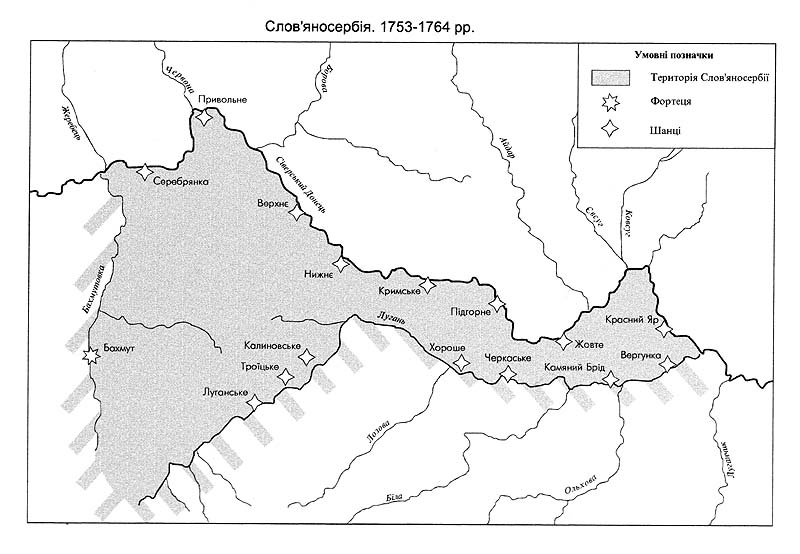
English: Map of the location of historical New Serbia (1752-1764) and Slavo-Serbia (1753-1764) and comparison with the location of modern provinces of Ukraine. Српски / srpski: Мапа положаја Нове Србије (1752-1764) и Славеносрбије (1753-1764) и поређење са положајем данашњих покрајина Украјине. |
| Date | |
| Source | Own work |
| Author | PANONIAN |
Licensing edit
I, the copyright holder of this work, hereby publish it under the following license:
| This file is made available under the Creative Commons CC0 1.0 Universal Public Domain Dedication. | |
| The person who associated a work with this deed has dedicated the work to the public domain by waiving all of their rights to the work worldwide under copyright law, including all related and neighboring rights, to the extent allowed by law. You can copy, modify, distribute and perform the work, even for commercial purposes, all without asking permission.
|
References edit
- Mita Kostić, Nova Srbija i Slavenosrbija, Novi Sad, 2001.
- Olga M. Posunjko, Istorija Nove Srbije i Slavenosrbije, Novi Sad, 2002.
- Pavel Rudjakov, Seoba Srba u Rusiju u 18. veku, Beograd, 1995.
- http://www.rastko.rs/rastko-ukr/istorija/img/nova_serbija.jpg
- http://www.rastko.rs/rastko-ukr/istorija/img/sloveno_serbija.jpg
- http://www.irekw.internetdsl.pl/27_1727-1768.jpg archive copy at the Wayback Machine
- http://www.jewishgen.org/Ukraine/maps/Ukrainian-Land-1750.jpg
File history
Click on a date/time to view the file as it appeared at that time.
| Date/Time | Thumbnail | Dimensions | User | Comment | |
|---|---|---|---|---|---|
| current | 07:21, 15 June 2014 | | 1,121 × 770 (61 KB) | PANONIAN (talk | contribs) | {{Information |Description ={{en|1=Map of the location of historical New Serbia (1752-1764) and Slavo-Serbia (1753-1764) and comparison with the location of modern provinces of Ukraine.}} |Source ={{own}} |Author =[[User:PANONIAN|PAN... |
You cannot overwrite this file.
File usage on Commons
There are no pages that use this file.
File usage on other wikis
The following other wikis use this file:
- Usage on bg.wikipedia.org
- Usage on sr.wikipedia.org