File:Newcastle upon Tyne UK ward map 2018 (blank).svg

Size of this PNG preview of this SVG file: 655 × 600 pixels. Other resolutions: 262 × 240 pixels | 524 × 480 pixels | 839 × 768 pixels | 1,118 × 1,024 pixels | 2,236 × 2,048 pixels | 1,425 × 1,305 pixels.
Original file (SVG file, nominally 1,425 × 1,305 pixels, file size: 245 KB)
Captions
Captions
Add a one-line explanation of what this file represents
| Description |
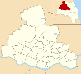
Map of Newcastle upon Tyne, Tyne and Wear, UK with 2018 electoral wards shown. Equirectangular map projection on WGS 84 datum, with N/S stretched 170% Geographic limits:
|
| Date | |
| Source |
|
| Author | Rcsprinter123, based on File:Newcastle upon Tyne UK ward map 2010 (blank).svg by Nilfanion, created using Ordnance Survey data |
| Permission (Reusing this file) |
This file is licensed under the Creative Commons Attribution-Share Alike 3.0 Unported license. Attribution: Contains Ordnance Survey data © Crown copyright and database right
|
.svg)
File history
Click on a date/time to view the file as it appeared at that time.
| Date/Time | Thumbnail | Dimensions | User | Comment | |
|---|---|---|---|---|---|
| current | 19:27, 14 February 2021 | | 1,425 × 1,305 (245 KB) | Rcsprinter123 (talk | contribs) | Uploaded own work with UploadWizard |
You cannot overwrite this file.
File usage on Commons
The following 3 pages use this file:
File usage on other wikis
The following other wikis use this file:
- Usage on en.wikipedia.org
.svg&oldid=673365865)