File:Niagara Falls Suspension Bridges.svg

Size of this PNG preview of this SVG file: 788 × 599 pixels. Other resolutions: 316 × 240 pixels | 631 × 480 pixels | 1,010 × 768 pixels | 1,280 × 974 pixels | 2,560 × 1,947 pixels | 1,295 × 985 pixels.
Original file (SVG file, nominally 1,295 × 985 pixels, file size: 271 KB)
Captions
Captions
Add a one-line explanation of what this file represents
Summary edit
| Description |
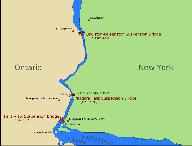
English: A map of the suspension bridges over the Niagara River. The towns of Queenson; Lewiston; Niagara Falls, New York; and Niagara Falls, Ontario, as well as the villages of Clifton and Suspension Bridge are shown here. |
| Date | |
| Source | Own work by uploader; based on Image:1904 NYCRR Buffalo.jpg and Image:Niagara Falls from space 2.jpg |
| Author | Jappalang |
This W3C-unspecified vector image was created with Inkscape .
Licensing edit
I, the copyright holder of this work, hereby publish it under the following licenses:
This file is licensed under the Creative Commons Attribution-Share Alike 3.0 Unported license.
- You are free:
- to share – to copy, distribute and transmit the work
- to remix – to adapt the work
- Under the following conditions:
- attribution – You must give appropriate credit, provide a link to the license, and indicate if changes were made. You may do so in any reasonable manner, but not in any way that suggests the licensor endorses you or your use.
- share alike – If you remix, transform, or build upon the material, you must distribute your contributions under the same or compatible license as the original.

|
Permission is granted to copy, distribute and/or modify this document under the terms of the GNU Free Documentation License, Version 1.2 or any later version published by the Free Software Foundation; with no Invariant Sections, no Front-Cover Texts, and no Back-Cover Texts. A copy of the license is included in the section entitled GNU Free Documentation License. |
You may select the license of your choice.
File history
Click on a date/time to view the file as it appeared at that time.
| Date/Time | Thumbnail | Dimensions | User | Comment | |
|---|---|---|---|---|---|
| current | 20:46, 8 April 2009 | | 1,295 × 985 (271 KB) | Jappalang (talk | contribs) | "Beautified" version, text rendered as paths |
| 13:47, 29 September 2008 |  | 1,295 × 985 (37 KB) | Jappalang (talk | contribs) | Category:Niagara Falls Suspension Bridge Category:Niagara Falls | |
| 13:36, 29 September 2008 |  | 1,295 × 985 (37 KB) | Jappalang (talk | contribs) | Re-added text | |
| 13:33, 29 September 2008 |  | 1,295 × 985 (36 KB) | Jappalang (talk | contribs) | <flowroot> deleted | |
| 13:28, 29 September 2008 |  | 1,295 × 985 (38 KB) | Jappalang (talk | contribs) | Stroked to path | |
| 13:23, 29 September 2008 |  | 1,295 × 985 (38 KB) | Jappalang (talk | contribs) | Fix page size of image | |
| 13:21, 29 September 2008 |  | 744 × 1,052 (37 KB) | Jappalang (talk | contribs) | {{Information |Description={{en|1=A map of the suspension bridges over the Niagara River. The towns of Queenson; Lewiston; Niagara Falls, New York; and Niagara Falls, Ontario, as well as the villages of Clifton and Suspension Bridge are shown here.}} |So |
You cannot overwrite this file.
File usage on Commons
The following page uses this file:
File usage on other wikis
The following other wikis use this file:
- Usage on fr.wikipedia.org
- Usage on it.wikipedia.org