File:Nicolas de Fer's map in which Lithuania proper (Vraye Lithuanie) is clearly separated with a green line from Samogitia (Samogitie), and the Belarusian territories of the Grand Duchy of Lithuania (Russie Blanche ou Lituanique).jpg

Size of this preview: 800 × 490 pixels. Other resolutions: 320 × 196 pixels | 640 × 392 pixels | 1,024 × 627 pixels | 1,280 × 784 pixels | 1,961 × 1,201 pixels.
Original file (1,961 × 1,201 pixels, file size: 1.3 MB, MIME type: image/jpeg)
Captions
Captions
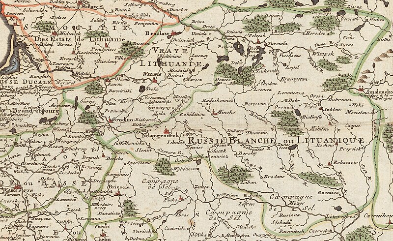
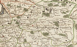
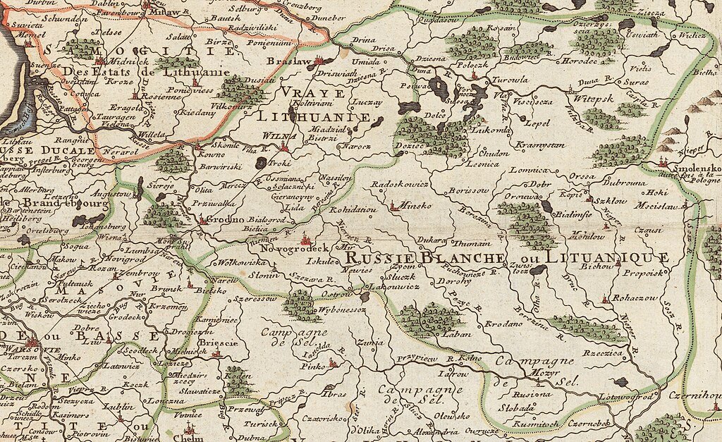
A fragment of an 18th-century map by Nicolas de Fer in which Lithuania proper (Vraye Lithuanie) is clearly separated with a green line from Samogitia and the Belarusian territories of the Grand Duchy of Lithuania (Russie Blanche ou Lituanique).
Summary edit
| Description |
English: A fragment of an 18th-century map by Nicolas de Fer in which Lithuania proper (
Vraye Lithuanie ), which the Lithuanian scientists consider as a state founding Baltic-origin core of the Grand Duchy of Lithuania,[1][2][3][4] is clearly separated with a green line from Samogitia (Samogitie) and the Belarusian territories of the Grand Duchy of Lithuania (Russie Blanche ou Lituanique ) and includes the cities of Vilnius, Kaunas, Trakai, Balbieriškis, Alytus, Ukmergė, Šalčininkai, Ashmyany, Grodno, Lida, Braslaw, etc.Lietuvių: Nikolajaus de Fero XVIII a. žemėlapio fragmentas, kuriame žalia linija aiškiai atskirta Tikroji Lietuva („Vraye Lithuanie”), kurią Lietuvos mokslininkai laiko valstybę įkūrusiu baltiškos kilmės Lietuvos Didžiosios Kunigaikštystės branduoliu, nuo Žemaitijos („Samogitie”) ir Lietuvos Didžiosios Kunigaikštystės baltarusiškų teritorijų („Russie Blanche ou Lituanique”) ir apima Vilnių, Kauną, Trakus, Balbieriškį, Alytų, Ukmergę, Šalčininkus, Ašmeną, Gardiną, Lydą, Breslaują ir kt. |
| Date | |
| Source |
Initial online source: Nlib.ee. Original of the map is in the National Library Cartography Collection. |
| Author | Nicolas de Fer (1646 – 25 October 1720) |

_is_clearly_separated_with_a_green_line_from_Samogitia_(Samogitie),_and_the_Belarusian_territories_of_the_Grand_Duchy_of_Lithuania_(Russie_Blanche_ou_Lituanique).jpg&action=edit§ion=1)
Licensing edit
_is_clearly_separated_with_a_green_line_from_Samogitia_(Samogitie),_and_the_Belarusian_territories_of_the_Grand_Duchy_of_Lithuania_(Russie_Blanche_ou_Lituanique).jpg&action=edit§ion=2)
|
This work is in the public domain in its country of origin and other countries and areas where the copyright term is the author's life plus 70 years or fewer. This work is in the public domain in the United States because it was published (or registered with the U.S. Copyright Office) before January 1, 1929. | |
| This file has been identified as being free of known restrictions under copyright law, including all related and neighboring rights. | |
References edit
_is_clearly_separated_with_a_green_line_from_Samogitia_(Samogitie),_and_the_Belarusian_territories_of_the_Grand_Duchy_of_Lithuania_(Russie_Blanche_ou_Lituanique).jpg&action=edit§ion=3)
- ↑ Didžioji Lietuva (in lt). Visuotinė lietuvių enciklopedija. Retrieved on 29 October 2023.
- ↑ Baltarusijos lietuviai (in lt). Visuotinė lietuvių enciklopedija. Retrieved on 29 October 2023.
- ↑ (1997). "Etnolingvistinė Rytų Lietuvos gyventojų raida XVII a. antrojoje pusėje - 1939 m: istorinė-geografinė analizė". Lituanistika.
- ↑ (1994). "Dėl pietryčių Lietuvos ankstyvųjų slavėjimo tarpsnių". Lietuvių kalbotyros klausimai XXXIV: 75–83.
File history
Click on a date/time to view the file as it appeared at that time.
| Date/Time | Thumbnail | Dimensions | User | Comment | |
|---|---|---|---|---|---|
| current | 14:11, 29 October 2023 | | 1,961 × 1,201 (1.3 MB) | Pofka (talk | contribs) | Uploaded a work by Nicolas de Fer (1646 – 25 October 1720) from {{extracted from|Carte des Estats de Suede, de Dannemarq, et de Pologne; sur la Mer Baltique.jpg}} Initial online source: [http://www.nlib.ee/html/digi/maps/kaart00280.jpg Nlib.ee]. Original of the map is in the National Library Cartography Collection. with UploadWizard |
You cannot overwrite this file.
File usage on Commons
The following 2 pages use this file:
File usage on other wikis
The following other wikis use this file:
- Usage on en.wikipedia.org
_is_clearly_separated_with_a_green_line_from_Samogitia_(Samogitie),_and_the_Belarusian_territories_of_the_Grand_Duchy_of_Lithuania_(Russie_Blanche_ou_Lituanique).jpg&oldid=863999625)