File:Niort (79), vue N-O.jpg

Size of this preview: 800 × 534 pixels. Other resolutions: 320 × 214 pixels | 640 × 428 pixels | 988 × 660 pixels.
Original file (988 × 660 pixels, file size: 335 KB, MIME type: image/jpeg)
Captions
Captions
Add a one-line explanation of what this file represents
Summary edit
,_vue_N-O.jpg&action=edit§ion=1)
| Description |
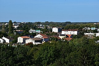
Français : Nord et ouest de l'agglomération niortaise depuis rue du Vivier, vers passerelle UGECAM. On aperçoit les portiques de signalisation de la rocade, qui franchit 2 fois la Sèvre.
Au fond sur la gauche, en limite d'image, immeubles du campus de Noron, siège de la MAIF depuis l'automne 79. La mutuelle avait auparavant son quartier général av. de Paris, plus près du centre ville. |
| Date | |
| Source | Own work |
| Author | Dacia 1410 Sport |
| Camera location | | View this and other nearby images on: OpenStreetMap |
|---|
,_vue_N-O.jpg¶ms=046.334930_N_-000.462280_E_globe:Earth_type:camera_heading:19.00&language=en)
Licensing edit
,_vue_N-O.jpg&action=edit§ion=2)
I, the copyright holder of this work, hereby publish it under the following license:
This file is licensed under the Creative Commons Attribution-Share Alike 4.0 International license.
- You are free:
- to share – to copy, distribute and transmit the work
- to remix – to adapt the work
- Under the following conditions:
- attribution – You must give appropriate credit, provide a link to the license, and indicate if changes were made. You may do so in any reasonable manner, but not in any way that suggests the licensor endorses you or your use.
- share alike – If you remix, transform, or build upon the material, you must distribute your contributions under the same or compatible license as the original.
File history
Click on a date/time to view the file as it appeared at that time.
| Date/Time | Thumbnail | Dimensions | User | Comment | |
|---|---|---|---|---|---|
| current | 04:21, 30 September 2022 | | 988 × 660 (335 KB) | Dacia 1410 Sport (talk | contribs) | Uploaded own work with UploadWizard |
You cannot overwrite this file.
File usage on Commons
There are no pages that use this file.
,_vue_N-O.jpg&oldid=754062461)