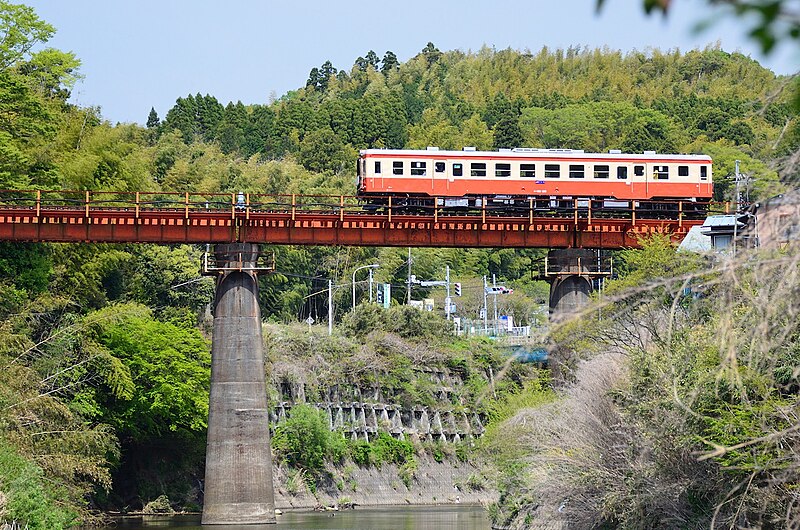
File:Kiha 52 125 rijdt over de brug nr.7 over de Isumi, -30 april 2011 a.jpg
(Redirected from File:Nishihata River 01.jpg)

Size of this preview: 800 × 530 pixels. Other resolutions: 320 × 212 pixels | 640 × 424 pixels | 1,024 × 678 pixels | 1,280 × 848 pixels.
Original file (1,280 × 848 pixels, file size: 574 KB, MIME type: image/jpeg)
File information
Structured data
Captions
Captions
Add a one-line explanation of what this file represents
Summary edit
| DescriptionKiha 52 125 rijdt over de brug nr.7 over de Isumi, -30 april 2011 a.jpg |
Nederlands: Dieselhydraulisch motorrijtuig Kiha 52 125 van de Isumi-lijn (richting Ōhara) rijdt over de brug nr.7 over de rivier de Isumi.
|
| Date | Taken on 30 April 2011 09:42 |
| Source | f:id:ksei:20110430094229j:image |
| Author | mnecho |
| Camera location | 35° 14′ 25.98″ N, 140° 14′ 43.98″ E | View this and other nearby images on: OpenStreetMap |
|---|
Licensing edit
This file is licensed under the Creative Commons Attribution-Share Alike 2.1 Japan license.
Attribution: mnecho
- You are free:
- to share – to copy, distribute and transmit the work
- to remix – to adapt the work
- Under the following conditions:
- attribution – You must give appropriate credit, provide a link to the license, and indicate if changes were made. You may do so in any reasonable manner, but not in any way that suggests the licensor endorses you or your use.
- share alike – If you remix, transform, or build upon the material, you must distribute your contributions under the same or compatible license as the original.

This file, which was originally posted to
f:id:ksei:20110430094229j:image
(Archived by WebCite® at https://www.webcitation.org/62hRTtOK8) See also the photographer's blog., was reviewed on 22 April 2013 by reviewer McZusatz, who confirmed that it was available there under the stated license on that date. |
File history
Click on a date/time to view the file as it appeared at that time.
| Date/Time | Thumbnail | Dimensions | User | Comment | |
|---|---|---|---|---|---|
| current | 14:14, 25 October 2011 |  | 1,280 × 848 (574 KB) | トトト (talk | contribs) | {{Information |Description={{ja|1=西畑川にかかるいすみ線の鉄橋。千葉県夷隅郡大多喜町三又。 --->地図は[http://www.mapion.co.jp/m/35.2373191666667 |
You cannot overwrite this file.
File usage on Commons
The following page uses this file:
- File:Nishihata River 01.jpg (file redirect)
File usage on other wikis
The following other wikis use this file:
- Usage on en.wikipedia.org
Metadata
This file contains additional information such as Exif metadata which may have been added by the digital camera, scanner, or software program used to create or digitize it. If the file has been modified from its original state, some details such as the timestamp may not fully reflect those of the original file. The timestamp is only as accurate as the clock in the camera, and it may be completely wrong.
| Camera manufacturer | NIKON CORPORATION |
|---|---|
| Camera model | NIKON D7000 |
| Exposure time | 1/1,000 sec (0.001) |
| F-number | f/5.6 |
| ISO speed rating | 800 |
| Date and time of data generation | 09:42, 30 April 2011 |
| Lens focal length | 100 mm |
| Orientation | Normal |
| Horizontal resolution | 300 dpi |
| Vertical resolution | 300 dpi |
| Software used | ViewNX 2.0 M |
| Exposure Program | Aperture priority |
| Exif version | 2.3 |
| Date and time of digitizing | 09:42, 30 April 2011 |
| APEX exposure bias | 0.66666666666667 |
| Maximum land aperture | 4.9 APEX (f/5.46) |
| Metering mode | Pattern |
| Light source | Unknown |
| Flash | Flash did not fire, compulsory flash suppression |
| DateTime subseconds | 70 |
| DateTimeOriginal subseconds | 70 |
| DateTimeDigitized subseconds | 70 |
| Supported Flashpix version | 1 |
| Color space | Uncalibrated |
| Sensing method | One-chip color area sensor |
| Custom image processing | Normal process |
| Exposure mode | Auto exposure |
| White balance | Auto white balance |
| Digital zoom ratio | 1 |
| Focal length in 35 mm film | 150 mm |
| Scene capture type | Standard |
| Scene control | Low gain up |
| Contrast | Normal |
| Saturation | Normal |
| Sharpness | Normal |
| Subject distance range | Unknown |