File:Nishinoshima mlit1978.jpg
Size of this preview: 800 × 600 pixels. Other resolutions: 320 × 240 pixels | 640 × 480 pixels | 1,024 × 768 pixels.
Original file (1,024 × 768 pixels, file size: 145 KB, MIME type: image/jpeg)
Captions
Captions
Add a one-line explanation of what this file represents
Summary edit
| Description |
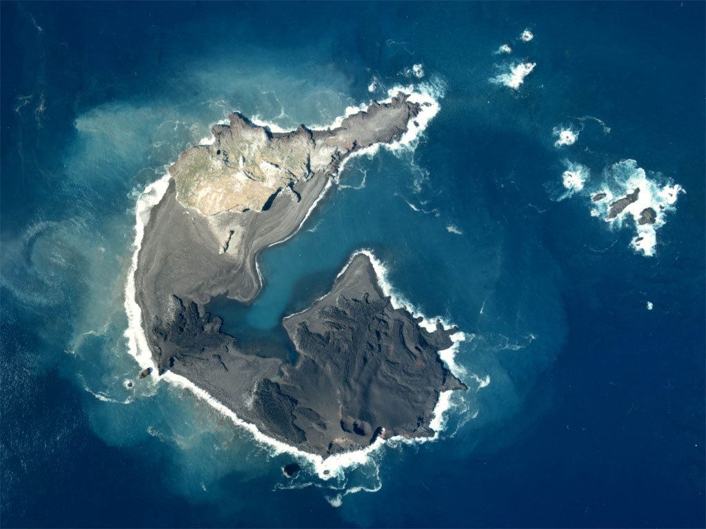
English: Aerial Photograph of Nishinoshima(Ogasawara Islands) at Japan in 1978. Last eruption is 1974.
日本語: 西之島および西之島新島の航空写真(1978年)。西之島は1973年に噴火し、新島を形成。新島はその後、西之島(写真上側)と接合した。 |
| Date | |
| Source | http://w3land.mlit.go.jp/Air/photo400/78/ckt-78-4/c6/ckt-78-4_c6_2.jpg |
| Author | Tdk |
Licensing edit

|
The copyright holder of this file, the Ministry of Land, Infrastructure, Transport and Tourism of Japan, allows anyone to use it for any purpose, provided that the copyright holder is properly attributed. Redistribution, derivative work, commercial use, and all other use is permitted. |
Attribution:
Copyright © National Land Image Information (Color Aerial Photographs), Ministry of Land, Infrastructure, Transport and Tourism
|
 |
This image is copyrighted by the Ministry of Land, Infrastructure, Transport and Tourism of Japan. For terms of use, see the stipulation to use of National Land Information (in Japanese) and message from MLIT (in Japanese and English). When you display this image on an article, include the following phrase in the description: "Made based on National Land Image Information (Color Aerial Photographs), Ministry of Land, Infrastructure, Transport and Tourism".
|
File history
Click on a date/time to view the file as it appeared at that time.
| Date/Time | Thumbnail | Dimensions | User | Comment | |
|---|---|---|---|---|---|
| current | 15:04, 27 April 2008 | | 1,024 × 768 (145 KB) | Tdk~commonswiki (talk | contribs) | {{Information |Description=en:Aerial Photograph of Nishinoshima(Ogasawara Islands)at Japan in 1978. Last eruption is 1974. ja:西之島および西之島新島の航空写真(1978年)。西之島は1973年に噴火し、新島を形成。新島はそ |
You cannot overwrite this file.
File usage on Commons
There are no pages that use this file.
File usage on other wikis
The following other wikis use this file:
- Usage on ar.wikipedia.org
- Usage on cs.wikipedia.org
- Usage on de.wikipedia.org
- Usage on en.wikipedia.org
- Usage on es.wikipedia.org
- Usage on ja.wikipedia.org
- Usage on ko.wikipedia.org
- Usage on nl.wikipedia.org
- Usage on pl.wikipedia.org
- Usage on ru.wikipedia.org
- Usage on sk.wikipedia.org
- Usage on uk.wikipedia.org
- Usage on zh.wikipedia.org