File:Noahsworld map.png

Size of this preview: 402 × 599 pixels. Other resolutions: 161 × 240 pixels | 322 × 480 pixels.
Original file (800 × 1,192 pixels, file size: 337 KB, MIME type: image/png)
Captions
Captions
Add a one-line explanation of what this file represents
| Description |
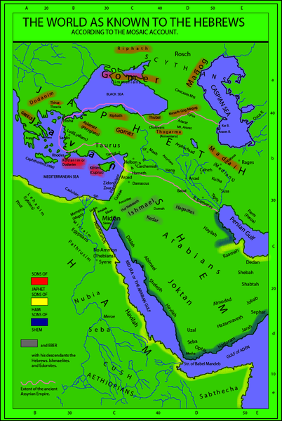
English: The world as known to the Hebrews. A map from "Historical Textbook and Atlas of Biblical Geography (1854)" by Lyman Coleman |
||||||||||||||
| Date | |||||||||||||||
| Source |
|
||||||||||||||
| Author |
|
||||||||||||||
| Permission (Reusing this file) |
|
||||||||||||||
| Other versions |
This map derives from a 1854 map   |
||||||||||||||
_(14793127233)_(cropped).jpg)
File history
Click on a date/time to view the file as it appeared at that time.
| Date/Time | Thumbnail | Dimensions | User | Comment | |
|---|---|---|---|---|---|
| current | 20:18, 19 February 2010 | | 800 × 1,192 (337 KB) | Megistias (talk | contribs) | Added, Zidon, Zoar, Arpad, Aram, Arphachsad, Mash, Carchemish, Calneh, (Armenians) parentheses in Medians. Ludim, Amalek, Edom, Midian and Sinim. Kaspian, Kur R., |
| 14:40, 19 February 2010 |  | 800 × 1,192 (331 KB) | Megistias (talk | contribs) | {{Information |Description={{en|The World as known to the Hebrews. A map from Historical Textbook and Atlas of Biblical Geography (1854) by Coleman}} |Source= *map from Historical Textbook and Atlas of Biblical Geography (1854) by Coleman *Historical Orig |
You cannot overwrite this file.
File usage on Commons
The following 3 pages use this file:
File usage on other wikis
The following other wikis use this file:
- Usage on bo.wikipedia.org
- Usage on en.wikipedia.org
- Usage on ko.wikipedia.org