File:Nogales, Arizona near the International Border.jpg

Original file (2,816 × 2,112 pixels, file size: 2.39 MB, MIME type: image/jpeg)
Captions
Captions
Summary edit
| Description |
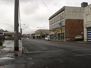
Nogales is a city in Santa Cruz County, Arizona, United States. The population was 20,878 at the 2000 census. According to 2005 Census Bureau estimates, the population of the city is 20,833.[2] The city is the county seat of Santa Cruz County.[3] Nogales, Arizona, borders the city of Nogales, Sonora, Mexico, and is Arizona's largest international border town. The southern terminus of Interstate 19 is located in Nogales at the U.S.-Mexico border; the highway continues south into Mexico as Mexico Federal Highway 15. Known in O'odham as Nowa:l[citation needed], the name Nogales means "walnuts" in Spanish, and the walnut trees which once grew abundantly in the mountain pass between the city of Nogales, Arizona and Nogales, Sonora can still be found around the town. According to the United States Census Bureau, the city has a total area of 20.8 square miles (53.9 km²), all of it land. Elevation: 3,865 ft. Nogales has a semi-arid steppe climate, which is less hot and more rainy than a typical arid climate classification. In the winter months, Nogales averages in the mid to upper 60s, with both January and February averaging daily highs of 64°F (18°C). Lows typically settle just below the freezing mark (32°F/0°C) on a majority of nights, but it is not uncommon to see temperatures tumble below 25°F (-4°C) on some winter nights. On the other hand, in the summer months, highs average between 90°F (32°C) and 100°F (38°C), with the month of June being the hottest with an average daytime high of 96°F (36°C). Nighttime lows for the summer months remain in the upper 50s and lower 60s for the duration of the season. June and July typically see eight inches or more of combined rainfall, which brings the average annual precipitation for Nogales to about 19 in (483 mm). Nogales' all-time highest recorded temperature is 112°F (44°C), which was reached on June 26, 1990. The all-time lowest recorded temperature that thermometers dipped to was -4°F (-20°C), which occurred on December 8, 1978. The name "Nogales" is derived from the Spanish word for "walnut" or "walnut tree." It refers to the large stands of walnut trees that once stood in the mountain pass where Nogales is located.[4] In 1841, a land grant from the Mexican government to the Elias family established Los Nogales de Elias. In 1880, Russian immigrant Jacob Isaacson built a trading post at present-day Nogales. The U.S. Postal Service opened the Isaacson Post Office but renamed it as Nogales in 1883.[5] In 1917, Nogales was the site of the last engagement in the Indian Wars. Most of Nogales's economy is based on agribusiness and produce distributors, which comes from large farms in the Mexican agri-belt. Despite its small population, Nogales actually receives much patronage from its bordering sister-city, Nogales, Sonora, Mexico. Most observers guess the population of Nogales, Sonora, at roughly 300,000[citation needed]. International commerce is a big part of Nogales’ economy[citation needed]. More than 60 percent of Nogales’ sales tax comes from Mexican shoppers crossing the border daily[citation needed]. Nogales, Arizona, and Nogales, Sonora, are home to one of the largest maquiladora clusters[citation needed]. This enables American manufacturing plants on both sides of the border to take advantage of favorable wage and operating costs and excellent transportation and distribution networks[citation needed]. The Consulate-General of El Salvador in Nogales is located in Suite 3 at 840 North Grand Avenue.[6] The Consulate-General of Mexico in Nogales is located on 571 North Grand Avenue.[7] The county of Santa Cruz and the city of Nogales have 200 properties listed in the National Register of Historic Sites, including Tumacacori National Monument visited by Father Kino in 1691 and Tubac Presidio, established by the Spanish in 1752 on an Indian village site. Others include the Old Tubac Schoolhouse, Old Nogales City Hall, Santa Cruz County Courthouse, and Patagonia Railroad Depot. The Patgonia-Sonoita Creek Sanctuary, 19 miles east, attracts worldwide visitors to see its diverse bird life. It is also host to ghost towns and mining camps, curio shops, first-class restaurants and night clubs. The Santa Cruz County Historical Courthouse on Morley Street/Court Street has the statue of Lady Justice on top of the building. Lady Justice is supposed to have a blindfold on holding the scales of justice. This symbolizes that justice is blind. The Nogales version of Lady Justice is not wearing a blindfold. As of the census[8] of 2000, there were 20,878 people, 5,985 households, and 4,937 families residing in the city. The population density was 1,002.1 people per square mile (387.0/km²). There were 6,501 housing units at an average density of 312.0/sq mi (120.5/km²). The racial makeup of the city was 77.83% White, 0.37% Black or African American, 0.57% Native American, 0.32% Asian, 0.07% Pacific Islander, 17.97% from other races, and 2.86% from two or more races. 93.59% of the population were Hispanic or Latino of any race. There were 5,985 households out of which 47.9% had children under the age of 18 living with them, 56.3% were married couples living together, 21.9% had a female householder with no husband present, and 17.5% were non-families. 15.1% of all households were made up of individuals and 7.6% had someone living alone who was 65 years of age or older. The average household size was 3.45 and the average family size was 3.86. In the city, the population was spread out with 34.6% under the age of 18, 9.5% from 18 to 24, 25.5% from 25 to 44, 19.5% from 45 to 64, and 10.8% who were 65 years of age or older. The median age was 30 years. For every 100 females there were 88.1 males. For every 100 females age 18 and over, there were 81.3 males. The median income for a household in the city was $22,306, and the median income for a family was $24,637. Males had a median income of $24,636 versus $18,403 for females. The per capita income for the city was $10,178. About 30.8% of families and 33.9% of the population were below the poverty line, including 41.2% of those under age 18 and 32.9% of those age 65 or over. en.wikipedia.org/wiki/Nogales,_Arizona Santa Cruz County is in the south of the U.S. state of Arizona. As of 2007, its population was estimated to be 42,845, an increase of 4,464 people since the 2000 census count of 38,381[1]. The county seat is Nogales.[2] Santa Cruz County contains Tumacácori National Historical Park. Santa Cruz County, created in 1899, is named after the Santa Cruz River which was named in the late 1600s by Father Kino. Santa Cruz means "holy cross" in Spanish. After that Father Kino built the famous mission which still stands today at the Tumacacori National Historic Park. According to the United States Census Bureau, the county has a total area of 1,238 square miles (3,207 km²), of which, 1,238 square miles (3,205 km²) of it is land and 0 square miles (1 km²) of it (0.04%) is water. Although Santa Cruz County is the smallest county in the State of Arizona, it is still larger in area than the national average of 1,611 km² (622 sq. miles) (See County (United States).) en.wikipedia.org/wiki/Santa_Cruz_County,_Arizona |
| Date | |
| Source |
Nogales, Arizona near the International Border
|
| Author | Ken Lund from Las Vegas, Nevada, USA |
| Camera location | | View this and other nearby images on: OpenStreetMap |
|---|
Licensing edit
- You are free:
- to share – to copy, distribute and transmit the work
- to remix – to adapt the work
- Under the following conditions:
- attribution – You must give appropriate credit, provide a link to the license, and indicate if changes were made. You may do so in any reasonable manner, but not in any way that suggests the licensor endorses you or your use.
- share alike – If you remix, transform, or build upon the material, you must distribute your contributions under the same or compatible license as the original.
| This image, originally posted to Flickr, was reviewed on January 21, 2012 by the administrator or reviewer File Upload Bot (Magnus Manske), who confirmed that it was available on Flickr under the stated license on that date. |
File history
Click on a date/time to view the file as it appeared at that time.
| Date/Time | Thumbnail | Dimensions | User | Comment | |
|---|---|---|---|---|---|
| current | 20:03, 21 January 2012 | | 2,816 × 2,112 (2.39 MB) | File Upload Bot (Magnus Manske) (talk | contribs) | {{Information |Description=Nogales is a city in Santa Cruz County, Arizona, United States. The population was 20,878 at the 2000 census. According to 2005 Census Bureau estimates, the population of the city is 20,833.[2] The city is the county seat of San |
You cannot overwrite this file.
File usage on Commons
There are no pages that use this file.
File usage on other wikis
The following other wikis use this file:
- Usage on de.wikipedia.org