File:Nordenskiöld 1897 Plate 32 Tabula Regionum Septentrionalium !5th Century.jpg

Size of this preview: 800 × 599 pixels. Other resolutions: 320 × 240 pixels | 640 × 479 pixels | 1,024 × 767 pixels | 1,280 × 959 pixels | 2,560 × 1,917 pixels | 7,341 × 5,498 pixels.
Original file (7,341 × 5,498 pixels, file size: 9.44 MB, MIME type: image/jpeg)
Captions
Captions
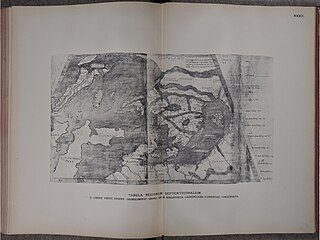
15th Century map of NW Europe
Summary edit
| Description |
English: Tabula Regionum Septentrinalium, facsilie map of the northern region, including Britain Scandiavia and Iceland from Periplus: an essay on the early history of charts and sailing directions. Nordenskiöld's description of the map is: "A map on Donis’ projection[...]. It occurs in a work written about 1420: Descriptio Cicladum aliarumque insularum by Christ. Ensentus (Buondelmonte). The MS., which is of the end of the 15th century, is preserved in the Laurentian Library at Florence (Plut. XXIX, Cod. 25, sec. XV). The map is here reproduced on pl. XXXII. Some remarks, unfortunately very incomplete, on the codex in which this map is inserted, are given by Assunrto Mort in La Groenlandia in due carte del XV secolo, Firenze 1895. Original map in the Laurentian Museum, Florence. |
| Date | |
| Source | Scan from original book |
| Author | book author: Nordenskiöld A.E. (Adolf Erik) 1832-1901 |
Licensing edit
|
This work is in the public domain in its country of origin and other countries and areas where the copyright term is the author's life plus 70 years or fewer. This work is in the public domain in the United States because it was published (or registered with the U.S. Copyright Office) before January 1, 1929. | |
| This file has been identified as being free of known restrictions under copyright law, including all related and neighboring rights. | |
File history
Click on a date/time to view the file as it appeared at that time.
| Date/Time | Thumbnail | Dimensions | User | Comment | |
|---|---|---|---|---|---|
| current | 14:18, 4 February 2024 | | 7,341 × 5,498 (9.44 MB) | Kognos (talk | contribs) | Uploaded a work by book author: Nordenskiöld A.E. (Adolf Erik) 1832-1901 from Scan from original book with UploadWizard |
You cannot overwrite this file.
File usage on Commons
The following page uses this file: