File:Nordrhein-Westfalen-Lippe innerhalb der britischen Besatzungszone 1946.svg

Size of this PNG preview of this SVG file: 492 × 600 pixels. Other resolutions: 197 × 240 pixels | 394 × 480 pixels | 630 × 768 pixels | 840 × 1,024 pixels | 1,680 × 2,048 pixels | 512 × 624 pixels.
Original file (SVG file, nominally 512 × 624 pixels, file size: 534 KB)
Captions
Captions
Add a one-line explanation of what this file represents
Summary edit
| Description |
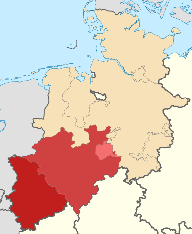
Nederlands: Noord-Rijnland, Westfalen en Lippe in de Britse bezettingszone in Duitsland, deze gebieden vormden in 1947 Noordrijn-Westfalen.
Deutsch: Karte der Provinz Nordrheinland, Westfalen und Freistaat Lippe innerhalb der britischen Besatzungszone, Stand: 1. Januar 1946, mit heutigem Küstenverlauf
English: Map of the Province Nordrheinland, Westfalen and Freistaat Lippe in the British Zone of Occupation
|
| Date | |
| Source | Own work derived from File:Rheinland innerhalb der britischen Besatzungszone 1946.svg by NordNordWest |
| Author | Hans Erren |
Licensing edit
I, the copyright holder of this work, hereby publish it under the following license:
This file is licensed under the Creative Commons Attribution-Share Alike 4.0 International license.
- You are free:
- to share – to copy, distribute and transmit the work
- to remix – to adapt the work
- Under the following conditions:
- attribution – You must give appropriate credit, provide a link to the license, and indicate if changes were made. You may do so in any reasonable manner, but not in any way that suggests the licensor endorses you or your use.
- share alike – If you remix, transform, or build upon the material, you must distribute your contributions under the same or compatible license as the original.
File history
Click on a date/time to view the file as it appeared at that time.
| Date/Time | Thumbnail | Dimensions | User | Comment | |
|---|---|---|---|---|---|
| current | 20:56, 24 November 2016 | | 512 × 624 (534 KB) | Hans Erren (talk | contribs) | User created page with UploadWizard |
You cannot overwrite this file.
File usage on Commons
The following page uses this file:
File usage on other wikis
The following other wikis use this file:
- Usage on de.wikipedia.org
- Usage on nl.wikipedia.org