File:North American blizzard of 2016 seen by RapidScat on 2016-01-23 (PIA20366).jpg

No higher resolution available.
North_American_blizzard_of_2016_seen_by_RapidScat_on_2016-01-23_(PIA20366).jpg (751 × 479 pixels, file size: 73 KB, MIME type: image/jpeg)
Captions
Captions
Add a one-line explanation of what this file represents
Summary edit
.jpg&action=edit§ion=1)
| Description |
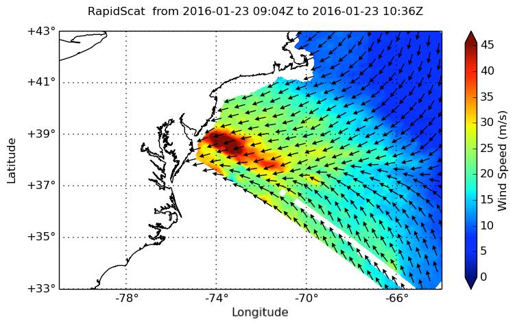
English: NASA's ISS-RapidScat instrument on the International Space Station provided a look at the strong winds that led to coastal flooding in southern New Jersey during the historic winter storm that blanketed much of the U.S. East Coast, starting Jan. 23, 2016. At 2 a.m. PST on Jan. 23, RapidScat showed sustained winds as strong as 45 meters per second (100 mph/162 kilometers per hour) along the coast of southern New Jersey. Many beachfront towns in this region were flooded as winds pushed ocean waters inland. The town of Cape May, New Jersey, reported a flood level of 8.98 feet (2.74 meters) -- the highest on record.
This image shows ocean winds near the surface off the U.S. East Coast, from the hook of Cape Cod at top center to the South Carolina coastline at bottom left. Southern New Jersey and the northern edge of Delaware are directly in the path of the highest wind speeds. |
| Date | |
| Source | https://photojournal.jpl.nasa.gov/catalog/PIA20366 (image link) |
| Author | NASA/JPL-Caltech |
This image or video was catalogued by Jet Propulsion Laboratory of the United States National Aeronautics and Space Administration (NASA) under Photo ID: PIA20366. This tag does not indicate the copyright status of the attached work. A normal copyright tag is still required. See Commons:Licensing. Other languages:
|
Licensing edit
.jpg&action=edit§ion=2)
| This file is in the public domain in the United States because it was solely created by NASA. NASA copyright policy states that "NASA material is not protected by copyright unless noted". (See Template:PD-USGov, NASA copyright policy page or JPL Image Use Policy.) | ||
 |
Warnings:
|
File history
Click on a date/time to view the file as it appeared at that time.
| Date/Time | Thumbnail | Dimensions | User | Comment | |
|---|---|---|---|---|---|
| current | 02:12, 16 January 2018 | | 751 × 479 (73 KB) | Huntster (talk | contribs) | {{Information |Description={{en|1=NASA's ISS-RapidScat instrument on the International Space Station provided a look at the strong winds that led to coastal flooding in southern New Jersey during the historic winter storm that blanketed much of the U.S... |
You cannot overwrite this file.
File usage on Commons
The following page uses this file:
.jpg&oldid=745305763)