File:North east coalfield.jpg

Size of this preview: 417 × 599 pixels. Other resolutions: 167 × 240 pixels | 334 × 480 pixels | 767 × 1,101 pixels.
Original file (767 × 1,101 pixels, file size: 298 KB, MIME type: image/jpeg)
Captions
Captions
Add a one-line explanation of what this file represents
Summary edit
| Description |
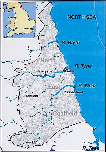
English: The coalfield of north east England and its rivers.
Acknowledgments and sources: The location of the coalfield is from Nicholas Wood, On the improvements and progress in the working and ventilation of coal mines in the Newcastle-on-Tyne district within the last fifty years, Proceedings of the Institution of Mechanical Engineers, 1858, plate XII. The base map (rivers and coastline of NE England) is selected from the open source Open Historical Maps. The inset outline map of England is from File:England in the uk outline map.png (Wikimedia Commons, by ChrisO modified by User:Xhandler). |
| Date | |
| Source | Own work |
| Author | Ttocserp |
Licensing edit
I, the copyright holder of this work, hereby publish it under the following license:
This file is licensed under the Creative Commons Attribution-Share Alike 4.0 International license.
- You are free:
- to share – to copy, distribute and transmit the work
- to remix – to adapt the work
- Under the following conditions:
- attribution – You must give appropriate credit, provide a link to the license, and indicate if changes were made. You may do so in any reasonable manner, but not in any way that suggests the licensor endorses you or your use.
- share alike – If you remix, transform, or build upon the material, you must distribute your contributions under the same or compatible license as the original.
File history
Click on a date/time to view the file as it appeared at that time.
| Date/Time | Thumbnail | Dimensions | User | Comment | |
|---|---|---|---|---|---|
| current | 18:51, 29 March 2023 | | 767 × 1,101 (298 KB) | Ttocserp (talk | contribs) | Uploaded own work with UploadWizard |
You cannot overwrite this file.
File usage on Commons
There are no pages that use this file.
File usage on other wikis
The following other wikis use this file:
- Usage on en.wikipedia.org