File:Northeastern Europe ESA381348.jpg

Original file (1,300 × 1,802 pixels, file size: 3.15 MB, MIME type: image/jpeg)
Captions
Captions
Summary edit
| Description |
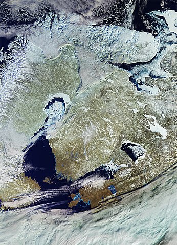
English: The Copernicus Sentinel-3 satellite takes us over the Baltic Sea and surrounding countries.
Snow, ice and clouds dominate the image, providing us with an overall view of the area’s climate when this image was captured on 6 March. Sentinel-3 offers a ‘bigger picture’ for Europe’s Copernicus programme by systematically measuring Earth’s oceans, land, ice and atmosphere to monitor and understand large-scale global dynamics. Finland is positioned at the centre of the image. The country has been called the ‘land of a thousand lakes’ – most of which are covered by ice and snow in this image. To its west is the Gulf of Bothnia, the northernmost arm of the Baltic Sea separating part of Finland from Sweden. Clouds on the lower left obstruct our view of the Swedish capital, Stockholm. In the upper left we can see part of Norway’s coastline with its famed fjords. During the ice age, ice and rivers carved deep valleys in the mountains. As the climate changed, most of the ice melted and the valleys were gradually filled with salt water from the coast, giving birth to the fjords. Russia dominates the right side of the image with the ice-covered Lake Onega and partially covered Lake Ladoga. Estonia is visible in the lower-central part of the image with significantly less snow cover, but with large areas of ice along its coast and on Lake Peipus. This image is featured on theEarth from Space video programme. |
| Date | |
| Source | http://www.esa.int/spaceinimages/Images/2017/07/Northeastern_Europe |
| Author | European Space Agency |
| Permission (Reusing this file) |
contains modified Copernicus Sentinel data (2017), processed by ESA,CC BY-SA 3.0 IGO |
| Other versions |
|
| Title | Northeastern Europe |
| Set | Earth observation image of the week |
| System | Copernicus |
| Mission | Sentinel-3 |
| Location | Estonia |
| Activity | Observing the Earth |
| Keywords | Lakes; Sea-ice; Snow; Ice and snow |

Licensing edit
- You are free:
- to share – to copy, distribute and transmit the work
- to remix – to adapt the work
- Under the following conditions:
- attribution – You must give appropriate credit, provide a link to the license, and indicate if changes were made. You may do so in any reasonable manner, but not in any way that suggests the licensor endorses you or your use.
- share alike – If you remix, transform, or build upon the material, you must distribute your contributions under the same or compatible license as the original.

|
This image contains data from a satellite in the Copernicus Programme, such as Sentinel-1, Sentinel-2 or Sentinel-3. Attribution is required when using this image.
Attribution: Contains modified Copernicus Sentinel data {{{year}}}
The use of Copernicus Sentinel Data is regulated under EU law (Commission Delegated Regulation (EU) No 1159/2013 and Regulation (EU) No 377/2014). Relevant excerpts:
Free access shall be given to GMES dedicated data [...] made available through GMES dissemination platforms [...].
Access to GMES dedicated data [...] shall be given for the purpose of the following use in so far as it is lawful:
GMES dedicated data [...] may be used worldwide without limitations in time.
GMES dedicated data and GMES service information are provided to users without any express or implied warranty, including as regards quality and suitability for any purpose. |
File history
Click on a date/time to view the file as it appeared at that time.
| Date/Time | Thumbnail | Dimensions | User | Comment | |
|---|---|---|---|---|---|
| current | 20:16, 25 July 2017 | | 1,300 × 1,802 (3.15 MB) | Fæ (talk | contribs) | European Space Agency, Id 381348, http://www.esa.int/spaceinimages/Images/2017/07/Northeastern_Europe, User:Fæ/Project_list/ESA |
| 20:16, 25 July 2017 |  | 1,300 × 1,802 (3.15 MB) | Fæ (talk | contribs) | European Space Agency, Id 381348, http://www.esa.int/spaceinimages/Images/2017/07/Northeastern_Europe, User:Fæ/Project_list/ESA | |
| 20:16, 25 July 2017 |  | 1,300 × 1,802 (3.15 MB) | Fæ (talk | contribs) | European Space Agency, Id 381348, http://www.esa.int/spaceinimages/Images/2017/07/Northeastern_Europe, User:Fæ/Project_list/ESA |
You cannot overwrite this file.
File usage on Commons
The following page uses this file:
File usage on other wikis
The following other wikis use this file:
- Usage on ru.wikipedia.org