File:NorthernIraqTerrain.jpg

Original file (2,780 × 1,840 pixels, file size: 3.72 MB, MIME type: image/jpeg)
Captions
Captions
Summary edit
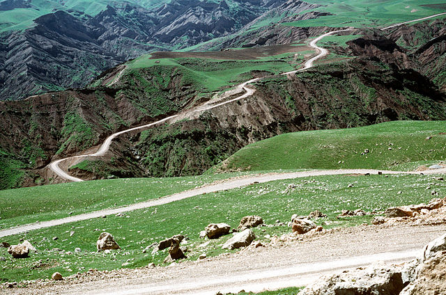
The territory in Northern Iraq where Operation Provide Comfort is taking place is hilly with poor road infrastructure. Operation Provide Comfort is a security mission to enforce the United Nations no-fly zone north of the 36 degree parallel from Iraqi air and ground incursion. A four nation coalition of U.S., Turkey, Great Britain and France has been actively protecting and supplying Kurdish refugees since Desert Storm in 1991.(Exact date unknown) (Released to Public)
DoD photo by: STAFF SGT. PAUL CARON Date Shot: 1 May 1995
Source: http://www.defenselink.mil/multimedia/
Licensing edit
This image is a work of a U.S. military or Department of Defense employee, taken or made as part of that person's official duties. As a work of the U.S. federal government, the image is in the public domain in the United States.
|
 |
File history
Click on a date/time to view the file as it appeared at that time.
| Date/Time | Thumbnail | Dimensions | User | Comment | |
|---|---|---|---|---|---|
| current | 03:38, 28 June 2007 | | 2,780 × 1,840 (3.72 MB) | Cla68 (talk | contribs) | The territory in Northern Iraq where Operation Provide Comfort is taking place is hilly with poor road infrastructure. Operation Provide Comfort is a security mission to enforce the United Nations no-fly zone north of the 36 degree parallel from Iraqi air |
You cannot overwrite this file.
File usage on Commons
The following page uses this file:
File usage on other wikis
The following other wikis use this file:
- Usage on ar.wikipedia.org
- Usage on bg.wikipedia.org
- Usage on en.wikipedia.org
- Usage on eo.wikipedia.org
- Usage on eo.wikivoyage.org
- Usage on es.wikipedia.org
- Usage on it.wikipedia.org
- Usage on nl.wikipedia.org
- Usage on pl.wikipedia.org
- Usage on ru.wikipedia.org