File:Novi Sad mun02.png

Size of this preview: 733 × 600 pixels. Other resolutions: 293 × 240 pixels | 587 × 480 pixels | 920 × 753 pixels.
Original file (920 × 753 pixels, file size: 56 KB, MIME type: image/png)
Captions
Captions
Add a one-line explanation of what this file represents
Summary edit
| Description |
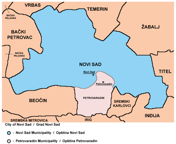
Map of Novi Sad City administrative area: Novi Sad and Petrovaradin municipalities.
|
| Date | 8 February 2009 (original upload date) |
| Source | No machine-readable source provided. Own work assumed (based on copyright claims). |
| Author | No machine-readable author provided. PANONIAN assumed (based on copyright claims). |
Source and license edit
self made map by user:PANONIAN
Licensing edit
| I, the copyright holder of this work, release this work into the public domain. This applies worldwide. In some countries this may not be legally possible; if so: I grant anyone the right to use this work for any purpose, without any conditions, unless such conditions are required by law. |
References edit
- Geografski atlas, Magic Map, Smederevska Palanka, 2001.
- Geografski atlas, Intersistem Kartografija, Beograd, 2004.
- Denis Šehić - Demir Šehić, Geografski atlas Srbije, Beograd, 2007.
- Dr Slobodan Ćurčić, Naselja Bačke - geografske karakteristike, Novi Sad, 2007.
- http://vajdasag.rs/images/0/02/Vajdaság_autóstérképe.png archive copy at the Wayback Machine
- http://www.arhiurb.vojvodina.gov.rs/postavljen/3/2011%20jun%20%20RPP%20APV%20za%20web.jpg
- http://www.lokalnirazvoj.org/upload/Book/Image/2012_03/Vojvodina_Region.jpg
- http://www.skupstinavojvodine.gov.rs/Slike/opstine.gif archive copy at the Wayback Machine
- http://mapy.mk.cvut.cz/data/Jugoslavie-Yugoslavia/Serbia/Serbia_topo_1.100000/images/378%20Novi%20Sad.jpg
- http://media.popis2011.stat.rs/2011/prvi_rezultati.pdf
File history
Click on a date/time to view the file as it appeared at that time.
| Date/Time | Thumbnail | Dimensions | User | Comment | |
|---|---|---|---|---|---|
| current | 19:19, 20 February 2013 | | 920 × 753 (56 KB) | PANONIAN (talk | contribs) | {{Information |Description ={{en|1=correction}} |Source =correction |Author =correction |Date = |Permission = |other_versions = }} |
| 15:15, 1 February 2013 |  | 920 × 753 (52 KB) | PANONIAN (talk | contribs) | {{Information |Description ={{en|1=improved version}} |Source =improved version |Author =improved version |Date = |Permission = |other_versions = }} | |
| 13:08, 17 February 2009 |  | 672 × 514 (18 KB) | PANONIAN (talk | contribs) | ||
| 21:16, 8 February 2009 |  | 672 × 514 (20 KB) | PANONIAN (talk | contribs) | map of Novi Sad and Petrovaradin municipalities (self made) {{PD-self}} Category:Maps of municipalities of Vojvodina |
You cannot overwrite this file.
File usage on Commons
The following 2 pages use this file: