File:OSM Micronesian Federation.png

Original file (4,725 × 3,564 pixels, file size: 2.14 MB, MIME type: image/png)
Captions
Captions
Summary edit
| Description |
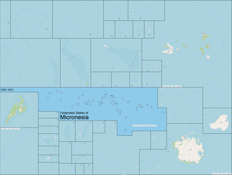
Deutsch: OSM-Übersichtskarte der Föderierten Staaten von Mikronesien.
Die Detailkarten 1-16 zeigen den Bundesstaat Yap (Detailkarte der Hauptinsel: #2). Die Detailkarten 17-29 zeigen den Bundesstaat Chuuk (Detailkarte der Hauptinseln: #27). Die Detailkarten 30-40 zeigen den Bundesstaat Pohnpei (Detailkarte der Hauptinsel: #38). Die Detailkarte 41 zeigt den Bundesstaat Kosrae. Die Hauptkarte (Hellblau) ist ein Screenshot der Standardansicht auf Zoomlevel 7. Alle Detailkarten (OSM-Meerblau) sind Aufnahmen der Standardansicht auf Zoomlevel 12 und haben daher denselben Maßstab. Dunkelblau gepunktete Flächen sind Riffe. Größenordnungsvergleiche: In die Ost-West-Ausdehnung zwischen Detailkarte 1-41 kann das ganze westliche Mittelmeer zwischen Gibraltar und Sizilien eingepasst werden; die gesamte Landfläche des Staates ist etwas geringer als die Fläche von Hamburg.English: OSM overview map of the Federated States of Micronesia,
Detail maps 1-16 show the state of Yap (main island detail map: #2). Detail maps 17-29 show the state of Chuuk (main islands detail map: #27). Detail maps 30-40 show the state of Pohnpei (main island detail map: #38). Detail map 41 shows the state of Kosrae. The central map in brighter blue is a screenshot of the standard OSM view on zoom level 7. All detail maps (OSM sea blue) are screenshots of standard view on zoom level 12, so that all of them are at the same scale. Blue-dotted areas are reefs, not counting towards land areas. Scale comparisons: The East-West expanse between detail maps 1 and 41 fits the southern seaboard of the United States (Miami to Texas). The total land area of the state is a bit smaller than Singapore. |
| Date | |
| Source | OpenStreetMap (www.OSM.org) |
| Author | OpenStreetMap contributors |
Licensing edit
- You are free:
- to share – to copy, distribute and transmit the work
- to remix – to adapt the work
- Under the following conditions:
- attribution – You must give appropriate credit, provide a link to the license, and indicate if changes were made. You may do so in any reasonable manner, but not in any way that suggests the licensor endorses you or your use.
- share alike – If you remix, transform, or build upon the material, you must distribute your contributions under the same or compatible license as the original.
File history
Click on a date/time to view the file as it appeared at that time.
| Date/Time | Thumbnail | Dimensions | User | Comment | |
|---|---|---|---|---|---|
| current | 16:06, 10 August 2023 | | 4,725 × 3,564 (2.14 MB) | Enyavar (talk | contribs) | wrong upload - replaced working edition with final file |
| 16:05, 10 August 2023 |  | 8,464 × 6,136 (1.43 MB) | Enyavar (talk | contribs) | Uploaded a work by OpenStreetMap contributors from OpenStreetMap (www.OSM.org) with UploadWizard |
You cannot overwrite this file.
File usage on Commons
There are no pages that use this file.