File:OSM Parque Natural Quebrada de Macul.png

Size of this preview: 800 × 376 pixels. Other resolutions: 320 × 150 pixels | 640 × 301 pixels | 1,360 × 639 pixels.
Original file (1,360 × 639 pixels, file size: 833 KB, MIME type: image/png)
Captions
Captions
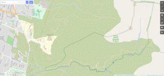
Quebrada de Macul Natural Park boundary, in OpenStreetMap
Summary edit
| Description |
Español: Mapa del Parque Natural Quebrada de Macul, renderizado en OpenStreetMap.
English: Map of Quebrada de Macul Natural Park, rendered in OpenStreetMap. |
|||
| Date | ||||
| Source | openstreetmap.org | |||
| Creator |
OpenStreetMap contributors |
|||
| Permission (Reusing this file) |
OpenStreetMap data is available under the Open Database License (details). Standard style map tiles are licensed as ODbL Produced Works.
|
|||
| Georeferencing | If inappropriate please set warp_status = skip to hide. |
| Camera location | | View this and other nearby images on: OpenStreetMap |
|---|
File history
Click on a date/time to view the file as it appeared at that time.
| Date/Time | Thumbnail | Dimensions | User | Comment | |
|---|---|---|---|---|---|
| current | 19:43, 5 December 2022 | | 1,360 × 639 (833 KB) | Pdassori (talk | contribs) | Uploaded own work with UploadWizard |
You cannot overwrite this file.
File usage on Commons
There are no pages that use this file.
File usage on other wikis
The following other wikis use this file:
- Usage on es.wikipedia.org