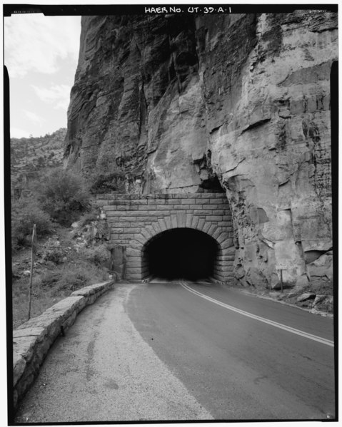
File:OVERALL VIEW OF WEST PORTAL AND GUARDRAIL, LOOKING SOUTHEAST - Zion-Mount Carmel Highway, Tunnel, Two miles east of Zion Canyon Scenic Drive, Springdale, Washington County, UT HAER UTAH,27-SPDA.V,3A-1.tif

Original file (3,997 × 5,000 pixels, file size: 19.06 MB, MIME type: image/tiff)
Captions
Captions
Summary edit
| OVERALL VIEW OF WEST PORTAL AND GUARDRAIL, LOOKING SOUTHEAST - Zion-Mount Carmel Highway, Tunnel, Two miles east of Zion Canyon Scenic Drive, Springdale, Washington County, UT | ||||
|---|---|---|---|---|
| Photographer |
Fraser, Clayton B., creator |
|||
| Title |
OVERALL VIEW OF WEST PORTAL AND GUARDRAIL, LOOKING SOUTHEAST - Zion-Mount Carmel Highway, Tunnel, Two miles east of Zion Canyon Scenic Drive, Springdale, Washington County, UT |
|||
| Description |
Nevada Construction Company; Bureau of Public Roads; Finch, J B; Mitchell, R R; Campbell, K B; Jones, T A; Scott, R N; Gregory, Herbert E; Cement Gun Construction Company; US Geologrical Service; US Bureau of Mining; Crane, W R; Reynolds-Ely Construction Co; Case Construction Company; Shea and Shea; Jurale, James, historian; Fraser, Clayton B, photographer; Anderson, Michael, historian; Grogan, Brian C, photographer |
|||
| Depicted place | Utah; Washington County; Springdale | |||
| Date | 1984 | |||
| Dimensions | 4 x 5 in. | |||
| Current location |
Library of Congress Prints and Photographs Division Washington, D.C. 20540 USA http://hdl.loc.gov/loc.pnp/pp.print |
|||
| Accession number |
HAER UTAH,27-SPDA.V,3A-1 |
|||
| Credit line |
|
|||
| Notes |
The tunnel is the longest constructed vehicular tunnel in the National Park system (5,613'), and in the western United States at the time of its completion. Aspects of its construction are unique, such as initial boring through side galleries rather than entrance portals. The tunnel is also significant for its association with the Zion-Mount Carmel Highway, the most expensive and one of the most difficult highways constructed by the National Park Service at its completion in 1930.
|
|||
| Source | https://www.loc.gov/pictures/item/ut0271.photos.159082p | |||
| Permission (Reusing this file) |
|
|||

File history
Click on a date/time to view the file as it appeared at that time.
| Date/Time | Thumbnail | Dimensions | User | Comment | |
|---|---|---|---|---|---|
| current | 01:24, 4 August 2014 |  | 3,997 × 5,000 (19.06 MB) | Fæ (talk | contribs) | GWToolset: Creating mediafile for Fæ. HABS 2014-08-02 (3401:3600) |
You cannot overwrite this file.
File usage on Commons
The following page uses this file: