File:Occupation of Marshall Islands in April 1944 map.png

Size of this preview: 749 × 600 pixels. Other resolutions: 300 × 240 pixels | 600 × 480 pixels | 964 × 772 pixels.
Original file (964 × 772 pixels, file size: 619 KB, MIME type: image/png)
Captions
Captions
Add a one-line explanation of what this file represents
Summary edit
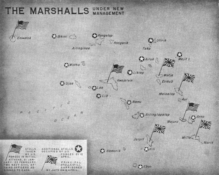
| Description | Contemporary map showing the Marshall islands held by the United States and the Empire of Japan on 12 April 1944. The islands still occupied by Japan were bypassed and surrendered at the end of the War. |
| Date | |
| Source | U.S. Navy All Hands magazine May 1944, p. 4. |
| Author | U.S. Navy |
| Permission (Reusing this file) |
"All photographs published in ALL HANDS are official Department of Defense photographs unless otherwise designated." |
Licensing edit
This image is a work of a U.S. military or Department of Defense employee, taken or made as part of that person's official duties. As a work of the U.S. federal government, the image is in the public domain in the United States.
|
 |
File history
Click on a date/time to view the file as it appeared at that time.
| Date/Time | Thumbnail | Dimensions | User | Comment | |
|---|---|---|---|---|---|
| current | 09:06, 23 October 2014 | | 964 × 772 (619 KB) | Cobatfor (talk | contribs) | == {{int:filedesc}} == {{Information |Description=Contemporary map showing the Marshall islands held by the United States and the Empire of Japan on 12 April 1944. The islands still occupied by Japan were bypassed and surrendered at the end of the War.... |
You cannot overwrite this file.
File usage on Commons
There are no pages that use this file.