File:Oceania regions map pt.svg

Size of this PNG preview of this SVG file: 800 × 587 pixels. Other resolutions: 320 × 235 pixels | 640 × 469 pixels | 1,024 × 751 pixels | 1,280 × 939 pixels | 2,560 × 1,877 pixels | 3,584 × 2,628 pixels.
Original file (SVG file, nominally 3,584 × 2,628 pixels, file size: 6.48 MB)
Captions
Captions
Add a one-line explanation of what this file represents
Summary edit
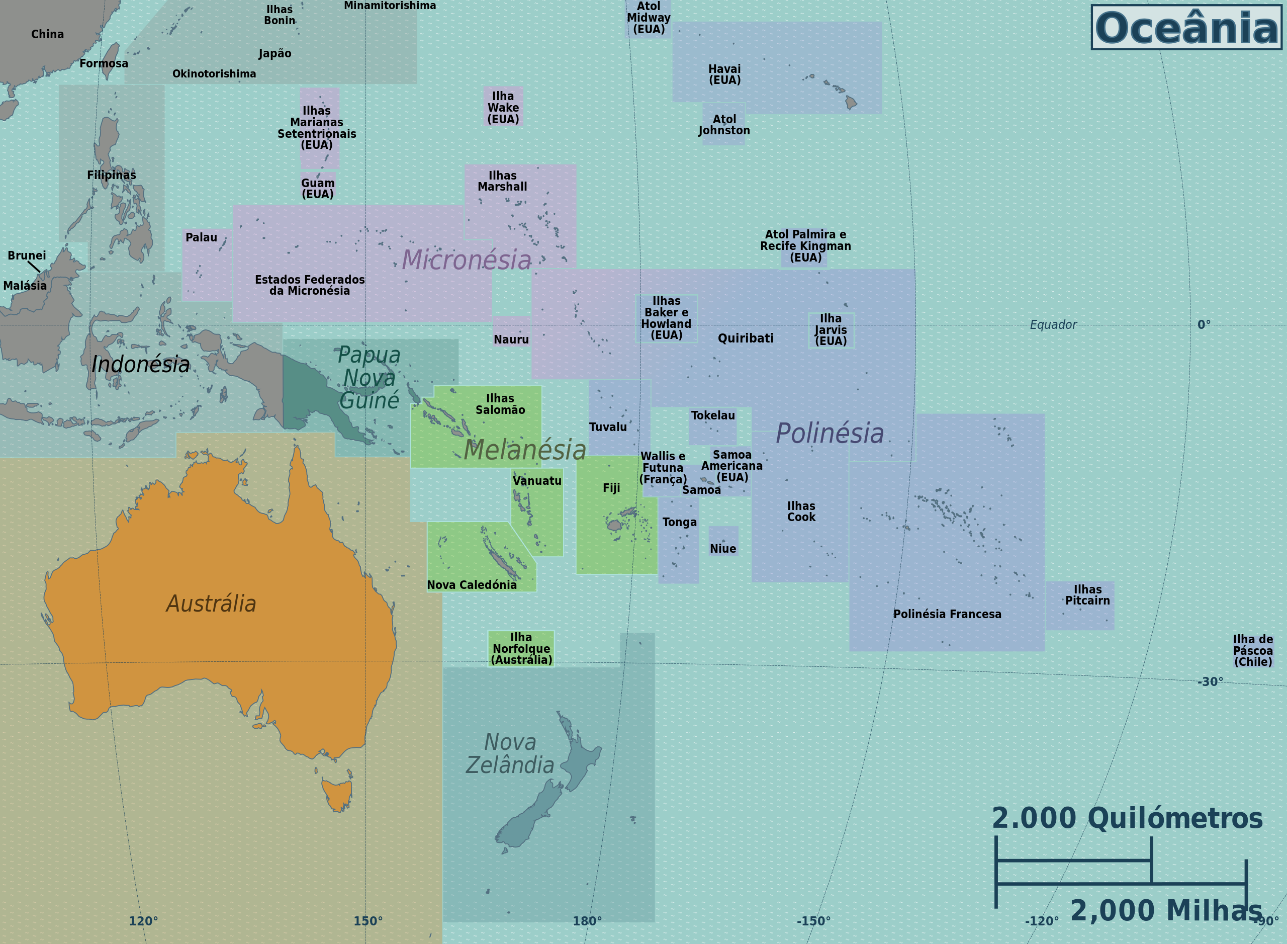
| Description | Mapa das regiões da Oceânia, ficheiro SVG multilingue |
| Date | |
| Source |
This file was derived from: Oceania regions map.svg: |
| Author |
|
| This is a retouched picture, which means that it has been digitally altered from its original version. Modifications: Portuguese language translation. The original can be viewed here: Oceania regions map.svg:
|
Licensing edit
I, the copyright holder of this work, hereby publish it under the following licenses:
This file is licensed under the Creative Commons Attribution-Share Alike 3.0 Unported license.
- You are free:
- to share – to copy, distribute and transmit the work
- to remix – to adapt the work
- Under the following conditions:
- attribution – You must give appropriate credit, provide a link to the license, and indicate if changes were made. You may do so in any reasonable manner, but not in any way that suggests the licensor endorses you or your use.
- share alike – If you remix, transform, or build upon the material, you must distribute your contributions under the same or compatible license as the original.

|
Permission is granted to copy, distribute and/or modify this document under the terms of the GNU Free Documentation License, Version 1.2 or any later version published by the Free Software Foundation; with no Invariant Sections, no Front-Cover Texts, and no Back-Cover Texts. A copy of the license is included in the section entitled GNU Free Documentation License. |
You may select the license of your choice.
Original upload log edit
This image is a derivative work of the following images:
- File:Oceania_regions_map.svg licensed with Cc-by-sa-3.0, GFDL
- 2012-11-28T16:29:26Z OgreBot 3584x2628 (6790019 Bytes) (BOT): Reverting to most recent version before archival
- 2012-11-28T16:29:16Z OgreBot 3584x2628 (6711505 Bytes) (BOT): Uploading old version of file from wts.wikivoyage-old; originally uploaded on 2011-09-29 05:20:05 by [[voy:User:(WT-shared) Joelf|(WT-shared) Joelf]]
- 2012-11-28T16:29:03Z OgreBot 990x765 (6634566 Bytes) (BOT): Uploading old version of file from wts.wikivoyage-old; originally uploaded on 2011-08-11 22:48:09 by [[voy:User:(WT-shared) Peterfitzgerald|(WT-shared) Peterfitzgerald]]
- 2012-11-28T16:28:53Z OgreBot 2350x1322 (6542490 Bytes) (BOT): Uploading old version of file from wts.wikivoyage-old; originally uploaded on 2011-08-01 18:51:27 by [[voy:User:(WT-shared) Peterfitzgerald|(WT-shared) Peterfitzgerald]]
- 2012-11-28T16:28:42Z OgreBot 2350x1322 (6535584 Bytes) (BOT): Uploading old version of file from wts.wikivoyage-old; originally uploaded on 2011-08-01 04:51:51 by [[voy:User:(WT-shared) Peterfitzgerald|(WT-shared) Peterfitzgerald]]
- 2012-11-28T16:28:29Z OgreBot 2350x1322 (6535531 Bytes) (BOT): Uploading old version of file from wts.wikivoyage-old; originally uploaded on 2011-08-01 04:45:54 by [[voy:User:(WT-shared) Peterfitzgerald|(WT-shared) Peterfitzgerald]]
- 2012-11-28T16:28:16Z OgreBot 2350x1322 (6535244 Bytes) (BOT): Uploading old version of file from wts.wikivoyage-old; originally uploaded on 2011-07-31 21:34:34 by [[voy:User:(WT-shared) Peterfitzgerald|(WT-shared) Peterfitzgerald]]
- 2012-11-28T16:28:02Z OgreBot 2350x1322 (6535199 Bytes) (BOT): Uploading old version of file from wts.wikivoyage-old; originally uploaded on 2011-07-31 21:30:45 by [[voy:User:(WT-shared) Peterfitzgerald|(WT-shared) Peterfitzgerald]]
- 2012-11-18T01:50:06Z MGA73bot2 3584x2628 (6790019 Bytes) {{BotMoveToCommons|wts.oldwikivoyage|year={{subst:CURRENTYEAR}}|month={{subst:CURRENTMONTHNAME}}|day={{subst:CURRENTDAY}}}} == {{int:filedesc}} == {{Information |description=Oceania regions map. SVG, Oceania * Map of: Oceania
Uploaded with derivativeFX
File history
Click on a date/time to view the file as it appeared at that time.
| Date/Time | Thumbnail | Dimensions | User | Comment | |
|---|---|---|---|---|---|
| current | 00:24, 18 May 2013 | | 3,584 × 2,628 (6.48 MB) | Tiago Penedo (talk | contribs) | == {{int:filedesc}} == {{Information |Description=Mapa das regiões da Oceânia, ficheiro SVG multilingue |date=2011-07-31 |Source={{Derived from|Oceania_regions_map.svg|display=50}} |Date=2013-05-18 00:06 (UTC) |Author=*[[:File:Oceania_regions_map.svg... |
| 00:14, 18 May 2013 |  | 3,584 × 2,628 (6.48 MB) | Tiago Penedo (talk | contribs) | == {{int:filedesc}} == {{Information |Description=Mapa das regiões da Oceânia, ficheiro SVG multilingue |date=2011-07-31 |Source={{Derived from|Oceania_regions_map.svg|display=50}} |Date=2013-05-18 00:06 (UTC) |Author=*[[:File:Oceania_regions_map.svg... |
You cannot overwrite this file.
File usage on Commons
There are no pages that use this file.
File usage on other wikis
The following other wikis use this file: