File:Okayama Castle map.jpg
Size of this preview: 562 × 599 pixels. Other resolutions: 225 × 240 pixels | 450 × 480 pixels | 720 × 768 pixels | 961 × 1,024 pixels | 2,454 × 2,616 pixels.
Original file (2,454 × 2,616 pixels, file size: 2.12 MB, MIME type: image/jpeg)
Captions
Captions
Add a one-line explanation of what this file represents
Summary edit
en edit
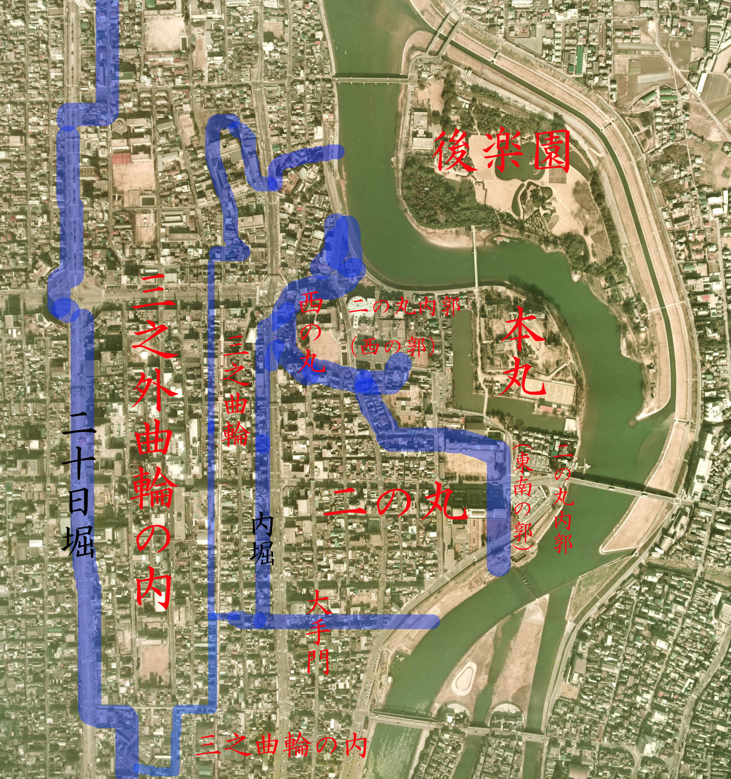
- Description: drew the territory on Aeral Photo of Okayama Castle and Korakuen garden, Okayama, Okayama, Japan
- Source: image from Country Picture Information (Color Aerial Photo) archive copy at the Wayback Machine resized and drew by Reggaeman
- Date: 1974
ja edit
- 説明: 岡山県岡山市にある岡山城と後楽園の空中写真上に岡山城縄張りを描いた
- 空中写真の北方向:

- 整理番号: CKK-74-12
- 撮影年度: 昭和49年度 (1974年度)
- 地区名:岡山
- 撮影縮尺: 1/8000
- 地形図番号:NI-53-27-1
- 撮影コース: C16B
- 写真番号: 17
- 空中写真の北方向:
- 出典: 国土画像情報 (カラー空中写真) archive copy at the Wayback Machineの写真を元にReggaemanにより編集・作成
Licensing edit

|
The copyright holder of this file, the Ministry of Land, Infrastructure, Transport and Tourism of Japan, allows anyone to use it for any purpose, provided that the copyright holder is properly attributed. Redistribution, derivative work, commercial use, and all other use is permitted. |
Attribution:
Copyright © National Land Image Information (Color Aerial Photographs), Ministry of Land, Infrastructure, Transport and Tourism
|
 |
This image is copyrighted by the Ministry of Land, Infrastructure, Transport and Tourism of Japan. For terms of use, see the stipulation to use of National Land Information (in Japanese) and message from MLIT (in Japanese and English). When you display this image on an article, include the following phrase in the description: "Made based on National Land Image Information (Color Aerial Photographs), Ministry of Land, Infrastructure, Transport and Tourism".
|
File history
Click on a date/time to view the file as it appeared at that time.
| Date/Time | Thumbnail | Dimensions | User | Comment | |
|---|---|---|---|---|---|
| current | 13:43, 11 June 2006 | | 2,454 × 2,616 (2.12 MB) | Reggaeman (talk | contribs) | == en == *'''Description:''' drew the territory on Aeral Photo of Okayama Castle and Korakuen garden, Okayama, Okayama, Japan *'''Source:''' image from [http://w3land.mlit.go.jp/WebGIS/ Country Picture Information (Color Aerial Photo)] resized and drew by |
| 13:40, 11 June 2006 |  | 2,454 × 2,616 (2.12 MB) | Reggaeman (talk | contribs) | == en == *'''Description:''' drew the territory on Aeral Photo of Okayama Castle and Korakuen garden, Okayama, Okayama, Japan *'''Source:''' image from [http://w3land.mlit.go.jp/WebGIS/ Country Picture Information (Color Aerial Photo)] resized and drew by |
You cannot overwrite this file.
File usage on Commons
The following page uses this file:
File usage on other wikis
The following other wikis use this file:
- Usage on da.wikipedia.org
- Usage on en.wikipedia.org
- Usage on fa.wikipedia.org
- Usage on it.wikipedia.org
- Usage on ja.wikipedia.org
- Usage on ko.wikipedia.org
- Usage on sl.wikipedia.org
- Usage on www.wikidata.org