File:Okinawajima nanbu - Nihon Nansei Shotō = Southern portion of Okinawa Sima - Nippon Nansei Syotō. LOC 2010446780.jpg

Size of this preview: 800 × 570 pixels. Other resolutions: 320 × 228 pixels | 640 × 456 pixels | 1,024 × 729 pixels | 1,280 × 911 pixels | 2,560 × 1,823 pixels | 16,958 × 12,074 pixels.
Original file (16,958 × 12,074 pixels, file size: 19 MB, MIME type: image/jpeg)
Captions
Captions
Add a one-line explanation of what this file represents
Summary edit
| Warning | The original file is very high-resolution. It might not load properly or could cause your browser to freeze when opened at full size. |
|---|
| Description |
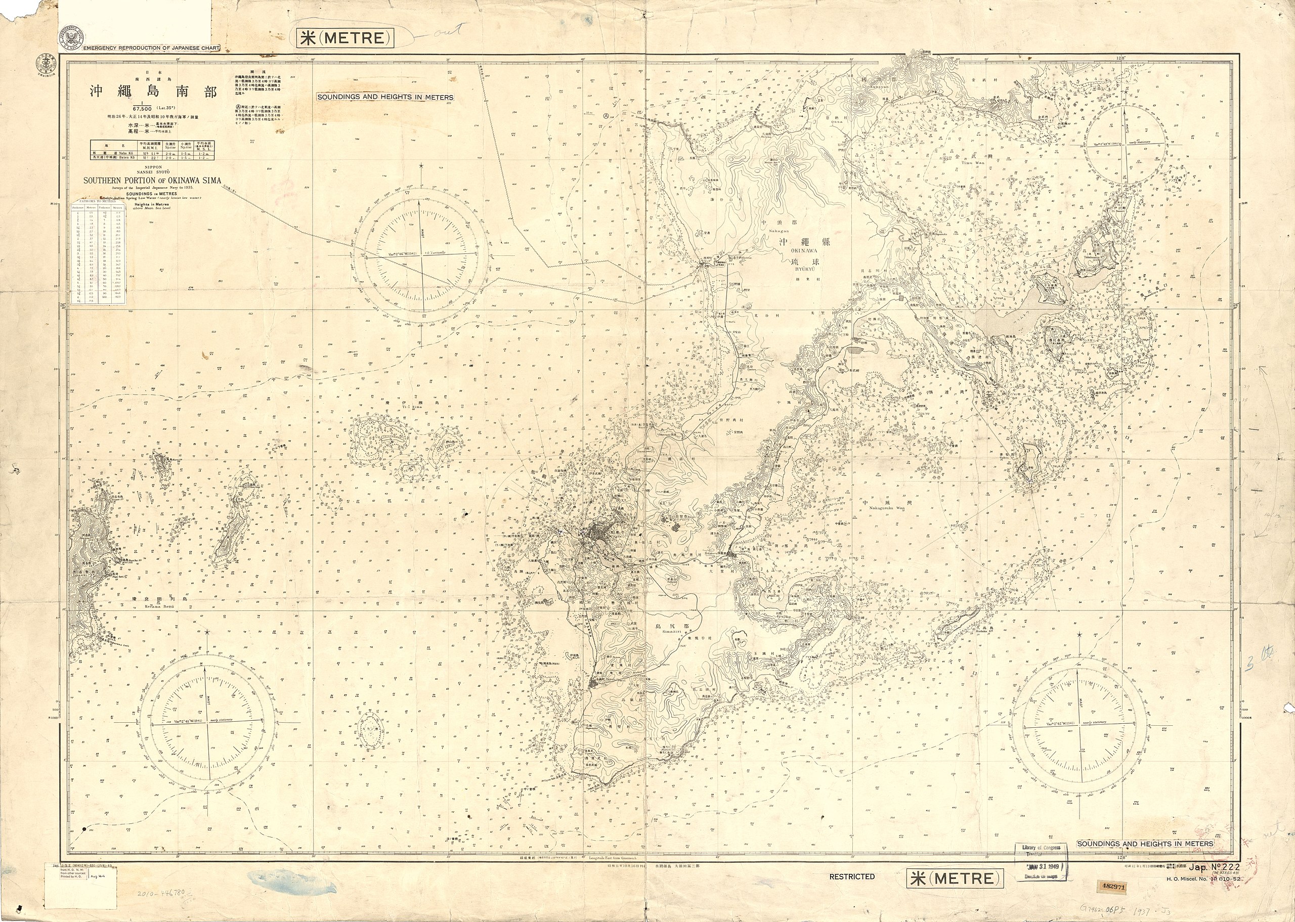
English: Possibly a draft prepared for reproduction by Hydrographic Office, U.S. Navy. Relief shown by contours and spot heights. Depths shown by soundings. A seal "Hydrographic Office, U.S. Navy"; and "Emergency reproduction of Japanese charts"--On a piece of paper pasted on map. "From H.O.N.M.: from other sources: Printed by H.O., Aug '44 [date handwritten]"; also "Soundings and heights in meters"; and "Fathoms to meters" (table)--Printed on pieces of paper pasted on map. "Jap. No. 222, H.O. miscel. no. 10 010-52" Available also through the Library of Congress Web site as a raster image. "佐世保鎮守府文庫"--Stamped. DLC On verso of map "増設タンク取付部" [design drawing of a machine in color]; with "佐世保鎮守府文庫 ... 昭和 16年 [1941] ..."; also "Condemned, July 16 1947" stamped. DLC |
||
| Title | Okinawajima nanbu : Nihon Nansei Shotō = Southern portion of Okinawa Sima : Nippon Nansei Syotō. | ||
| Shelf ID | G7962.O6P5 1937 .J3 | ||
| Date | |||
| Source | https://www.loc.gov/item/2010446780/ | ||
| Author | Japan. Kaigunshō. Suirobu; United States. Hydrographic Office | ||
| Permission (Reusing this file) |
|
||
| Other versions |
|
||
| Location | Okinawa Island · Japan | ||
| Part of | American Memory · General Maps · Catalog · Geography And Map Division | ||
| Subject | Japan · Nautical Charts · Okinawa Island |

Licensing edit
This work is in the public domain in the United States because it is a work prepared by an officer or employee of the United States Government as part of that person’s official duties under the terms of Title 17, Chapter 1, Section 105 of the US Code.
Note: This only applies to original works of the Federal Government and not to the work of any individual U.S. state, territory, commonwealth, county, municipality, or any other subdivision. This template also does not apply to postage stamp designs published by the United States Postal Service since 1978. (See § 313.6(C)(1) of Compendium of U.S. Copyright Office Practices). It also does not apply to certain US coins; see The US Mint Terms of Use.
|
 | |
| This file has been identified as being free of known restrictions under copyright law, including all related and neighboring rights. | ||
File history
Click on a date/time to view the file as it appeared at that time.
| Date/Time | Thumbnail | Dimensions | User | Comment | |
|---|---|---|---|---|---|
| current | 00:16, 19 May 2018 | | 16,958 × 12,074 (19 MB) | Fæ (talk | contribs) | LOC Maps https://www.loc.gov/item/2010446780/ #11068 |
You cannot overwrite this file.
File usage on Commons
The following page uses this file: