File:Oklahoma Congressional Districts, 118th Congress.svg

Size of this PNG preview of this SVG file: 800 × 451 pixels. Other resolutions: 320 × 180 pixels | 640 × 360 pixels | 1,024 × 577 pixels | 1,280 × 721 pixels | 2,560 × 1,442 pixels | 1,600 × 901 pixels.
Original file (SVG file, nominally 1,600 × 901 pixels, file size: 1.17 MB)
Captions
Captions
Add a one-line explanation of what this file represents
Summary edit
| Description |
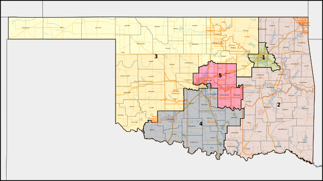
English: Map of the congressional districts of Oklahoma, complemented with county boundaries and American Indian areas (including Native reservations), as well as primary & secondary roads, urban areas, parks, and water areas in Oklahoma. These congressional districts are put into effect from 2023, following the 2022 US House elections. Shapefiles from the United States Census Bureau, converted with Mapshaper (Mercator projection). |
| Date | |
| Source | Own work |
| Author | Twotwofourtysix |
Licensing edit
I, the copyright holder of this work, hereby publish it under the following license:
This file is licensed under the Creative Commons Attribution-Share Alike 4.0 International license.
- You are free:
- to share – to copy, distribute and transmit the work
- to remix – to adapt the work
- Under the following conditions:
- attribution – You must give appropriate credit, provide a link to the license, and indicate if changes were made. You may do so in any reasonable manner, but not in any way that suggests the licensor endorses you or your use.
- share alike – If you remix, transform, or build upon the material, you must distribute your contributions under the same or compatible license as the original.
File history
Click on a date/time to view the file as it appeared at that time.
| Date/Time | Thumbnail | Dimensions | User | Comment | |
|---|---|---|---|---|---|
| current | 06:45, 19 April 2023 | | 1,600 × 901 (1.17 MB) | Twotwofourtysix (talk | contribs) | Uploaded own work with UploadWizard |
You cannot overwrite this file.
File usage on Commons
The following 2 pages use this file:
File usage on other wikis
The following other wikis use this file: