File:Old railway bridge at Travad 20070421.jpg
Size of this preview: 800 × 600 pixels. Other resolutions: 320 × 240 pixels | 640 × 480 pixels | 1,024 × 768 pixels | 1,280 × 960 pixels | 1,600 × 1,200 pixels.
Original file (1,600 × 1,200 pixels, file size: 894 KB, MIME type: image/jpeg)
File information
Structured data
Captions
Summary edit
DescriptionOld railway bridge at Travad 20070421.jpg |
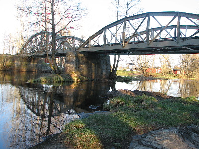
Svenska: Gammal järnvägsbro strax väster om Tråvad. Numera gång och cykelbro. Korsar Lidan. English: Old railway bridge west of Tråvad in Vara municipality. Now used as bike and pedestrian bridge. Crosses the river Lidan. |
Date | |
Source | Own work |
Author | Joel Grafström |
Camera location | 58° 15′ 12.02″ N, 13° 04′ 31.92″ E | View this and other nearby images on: OpenStreetMap | 58.253340; 13.075532 |
---|
Licensing edit
I, the copyright holder of this work, hereby publish it under the following license:
This file is licensed under the Creative Commons Attribution-Share Alike 3.0 Unported license.
- You are free:
- to share – to copy, distribute and transmit the work
- to remix – to adapt the work
- Under the following conditions:
- attribution – You must give appropriate credit, provide a link to the license, and indicate if changes were made. You may do so in any reasonable manner, but not in any way that suggests the licensor endorses you or your use.
- share alike – If you remix, transform, or build upon the material, you must distribute your contributions under the same or compatible license as the original.
File history
Click on a date/time to view the file as it appeared at that time.
Date/Time | Thumbnail | Dimensions | User | Comment | |
---|---|---|---|---|---|
current | 19:38, 28 March 2014 | 1,600 × 1,200 (894 KB) | Leojth (talk | contribs) | User created page with UploadWizard |
You cannot overwrite this file.
File usage on Commons
The following 2 pages use this file:
File usage on other wikis
The following other wikis use this file:
- Usage on sv.wikipedia.org
Metadata
This file contains additional information such as Exif metadata which may have been added by the digital camera, scanner, or software program used to create or digitize it. If the file has been modified from its original state, some details such as the timestamp may not fully reflect those of the original file. The timestamp is only as accurate as the clock in the camera, and it may be completely wrong.
Camera manufacturer | Canon |
---|---|
Camera model | Canon PowerShot S2 IS |
Exposure time | 1/60 sec (0.016666666666667) |
F-number | f/4 |
Date and time of data generation | 19:39, 21 April 2007 |
Lens focal length | 6 mm |
Latitude | 58° 15′ 12.02″ N |
Longitude | 13° 4′ 31.92″ E |
Altitude | 85 meters above sea level |
City that the picture was taken in | Vara kommun |
Orientation | Normal |
Horizontal resolution | 180 dpi |
Vertical resolution | 180 dpi |
File change date and time | 19:39, 21 April 2007 |
Y and C positioning | Centered |
Exif version | 2.2 |
Date and time of digitizing | 19:39, 21 April 2007 |
Meaning of each component |
|
Image compression mode | 3 |
APEX shutter speed | 5.90625 |
APEX aperture | 4 |
APEX exposure bias | 0 |
Maximum land aperture | 2.875 APEX (f/2.71) |
Metering mode | Pattern |
Flash | Flash did not fire, compulsory flash suppression |
Supported Flashpix version | 1 |
Color space | sRGB |
Focal plane X resolution | 7,111.1111111111 |
Focal plane Y resolution | 7,142.8571428571 |
Focal plane resolution unit | inches |
Sensing method | One-chip color area sensor |
File source | Digital still camera |
Custom image processing | Normal process |
Exposure mode | Auto exposure |
White balance | Auto white balance |
Digital zoom ratio | 1 |
Scene capture type | Standard |
Reference for direction of image | True direction |
Direction of image | 210 |
Latitude destination | 58° 15′ 11.79″ N |
Longitude of destination | 13° 4′ 32.94″ E |
Reference for bearing of destination | True direction |
Bearing of destination | 210 |
Reference for distance to destination | Kilometers |
Distance to destination | 0.018105563648095 |
GPS tag version | 0.0.3.2 |
Country that the picture was taken in | Sweden |
Province or state that the picture was taken in | Västra Götalands län |
Sublocation of the city that the picture was taken in | Tråvad |