File:Old view of Canterbury bus station - geograph.org.uk - 2300781.jpg
Old_view_of_Canterbury_bus_station_-_geograph.org.uk_-_2300781.jpg (640 × 429 pixels, file size: 159 KB, MIME type: image/jpeg)
File information
Structured data
Captions
Captions
Add a one-line explanation of what this file represents
Summary edit
| DescriptionOld view of Canterbury bus station - geograph.org.uk - 2300781.jpg |
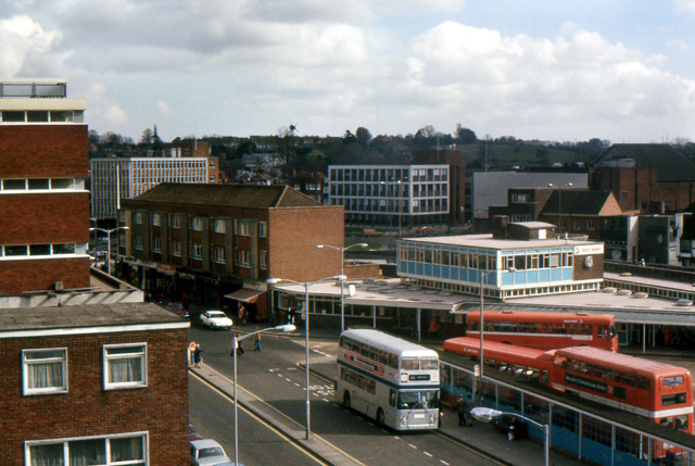
English: A view of Canterbury bus station from the multi storey car park, which was demolished to make way for the Whitefriars Shopping centre. The buses are in the NBC red and white livery of their East Kent subsidiary. According to the original author, the "The taken date is a best estimate", at 1980. The silver bus, also belonging to East Kent, possibly indicates the date is closer to 1977, as it's one of the various buses in various companies around the country that were painted silver to commemorate the Queen's Silver Jubilee. While many other companies used a variety of schemes, the as with many things the NBC seemed to take a standardised approach for their subsidiaries, applying the livery as an allover silver with blue band, while moving the fleetname & logo up & forward, to make way for a commemorative message in black between the wheelarches - as seen in this example of West Yorkshire's bus, a Bristol VR. This East Kent bus however is a Leyland Atlantean with ECW bodywork. The company took delivery of 15 of this chassis/body combination in 1976, numbering them 7001 to 7015, all registered in the series JJG 1P to JJG 15P. See this image of 7013 in the normal NBC red & white. |
| Date | |
| Source | From geograph.org.uk; transferred by User:Ultra7 using geograph_org2commons. |
| Author | Nick Smith |
| Permission (Reusing this file) |
Creative Commons Attribution Share-alike license 2.0 |
| Other versions |
 |
| Attribution (required by the license) InfoField | Nick Smith / |
InfoField | Nick Smith |
| Camera location | 51° 16′ 36.39″ N, 1° 04′ 53.45″ E | View this and other nearby images on: OpenStreetMap |
|---|
| Object location | 51° 16′ 36″ N, 1° 04′ 56″ E | View this and other nearby images on: OpenStreetMap |
|---|
Licensing edit

|
This image was taken from the Geograph project collection. See this photograph's page on the Geograph website for the photographer's contact details. The copyright on this image is owned by Nick Smith and is licensed for reuse under the Creative Commons Attribution-ShareAlike 2.0 license.
|
This file is licensed under the Creative Commons Attribution-Share Alike 2.0 Generic license.
Attribution: Nick Smith
- You are free:
- to share – to copy, distribute and transmit the work
- to remix – to adapt the work
- Under the following conditions:
- attribution – You must give appropriate credit, provide a link to the license, and indicate if changes were made. You may do so in any reasonable manner, but not in any way that suggests the licensor endorses you or your use.
- share alike – If you remix, transform, or build upon the material, you must distribute your contributions under the same or compatible license as the original.
File history
Click on a date/time to view the file as it appeared at that time.
| Date/Time | Thumbnail | Dimensions | User | Comment | |
|---|---|---|---|---|---|
| current | 15:30, 22 February 2012 |  | 640 × 429 (159 KB) | File Upload Bot (Magnus Manske) (talk | contribs) |
You cannot overwrite this file.
File usage on Commons
The following page uses this file:
Metadata
This file contains additional information such as Exif metadata which may have been added by the digital camera, scanner, or software program used to create or digitize it. If the file has been modified from its original state, some details such as the timestamp may not fully reflect those of the original file. The timestamp is only as accurate as the clock in the camera, and it may be completely wrong.
| Orientation | Normal |
|---|---|
| Horizontal resolution | 300 dpi |
| Vertical resolution | 300 dpi |
| Software used | Adobe Photoshop 7.0 |
| File change date and time | 18:00, 8 March 2011 |
| Color space | Uncalibrated |
