File:One 1910-08-28 weather map.jpg
No higher resolution available.
One_1910-08-28_weather_map.jpg (415 × 421 pixels, file size: 37 KB, MIME type: image/jpeg)
Captions
Captions
Add a one-line explanation of what this file represents
Summary
| Description | ||||
| Date | ||||
| Source | NOAA Central Library Data Imaging Project | |||
| Author | NOAA Central Library, Silver Spring, Maryland | |||
| Permission (Reusing this file) |
|
File history
Click on a date/time to view the file as it appeared at that time.
| Date/Time | Thumbnail | Dimensions | User | Comment | |
|---|---|---|---|---|---|
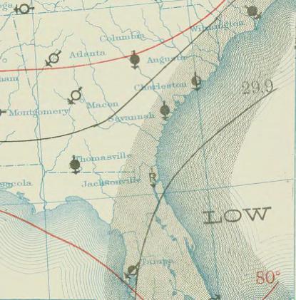
| current | 01:27, 24 April 2010 | | 415 × 421 (37 KB) | Juliancolton (talk | contribs) | {{Information |Description={{en|1=August 28, 1910 {{w|surface weather analysis}} of the remnants of Tropical Storm One off the coast of Florida. }} |Source=http://docs.lib.noaa.gov/rescue/dwm/1910/19100828.djvu |Author=[http://docs.lib.noaa.gov/rescue/dwm |
You cannot overwrite this file.
File usage on Commons
The following page uses this file:
- File:Tropical storm 1 1910 weather map.jpg (file redirect)
File usage on other wikis
The following other wikis use this file:
- Usage on en.wikipedia.org
- Usage on pt.wikipedia.org
- Usage on zh.wikipedia.org