File:Onze-Lieve-Vrouw der Zege Gedenkkapel 08.jpg

Size of this preview: 424 × 599 pixels. Other resolutions: 170 × 240 pixels | 340 × 480 pixels | 543 × 768 pixels | 724 × 1,024 pixels | 2,132 × 3,013 pixels.
Original file (2,132 × 3,013 pixels, file size: 1.92 MB, MIME type: image/jpeg)
Captions
Captions
Add a one-line explanation of what this file represents
Summary edit
| Description |
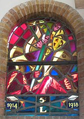
Nederlands: Een kubistisch brandglasraam van het 5de Regiment Lanciers dat verwijst naar Sint Joris in de Onze-Lieve-Vrouw der Zege Gedenkkapel |
| Date | |
| Source | Own work |
| Author | Frans90245 |
| Camera location | | View this and other nearby images on: OpenStreetMap |
|---|
De Onze-Lieve-Vrouw der Zege Gedenkkapel werd opgericht na de Eerste Wereldoorlog ter gedachtenis van de miraculeuze bescherming die Onze Lieve Vrouw zou geboden hebben.
Cavaleristen zoals het 5de Regiment Lanciers beschouwen Sint Joris als hun patroonheilige
Licensing edit
I, the copyright holder of this work, hereby publish it under the following license:
This file is licensed under the Creative Commons Attribution-Share Alike 4.0 International license.
- You are free:
- to share – to copy, distribute and transmit the work
- to remix – to adapt the work
- Under the following conditions:
- attribution – You must give appropriate credit, provide a link to the license, and indicate if changes were made. You may do so in any reasonable manner, but not in any way that suggests the licensor endorses you or your use.
- share alike – If you remix, transform, or build upon the material, you must distribute your contributions under the same or compatible license as the original.
File history
Click on a date/time to view the file as it appeared at that time.
| Date/Time | Thumbnail | Dimensions | User | Comment | |
|---|---|---|---|---|---|
| current | 17:16, 26 August 2019 | | 2,132 × 3,013 (1.92 MB) | Frans90245 (talk | contribs) | User created page with UploadWizard |
You cannot overwrite this file.
File usage on Commons
There are no pages that use this file.