File:Opening up DFIDs trade data in downtown Lagos (8102032716).jpg

Original file (1,936 × 1,936 pixels, file size: 1.23 MB, MIME type: image/jpeg)
Captions
Captions
Summary edit
.jpg&action=edit§ion=1)
| Description |
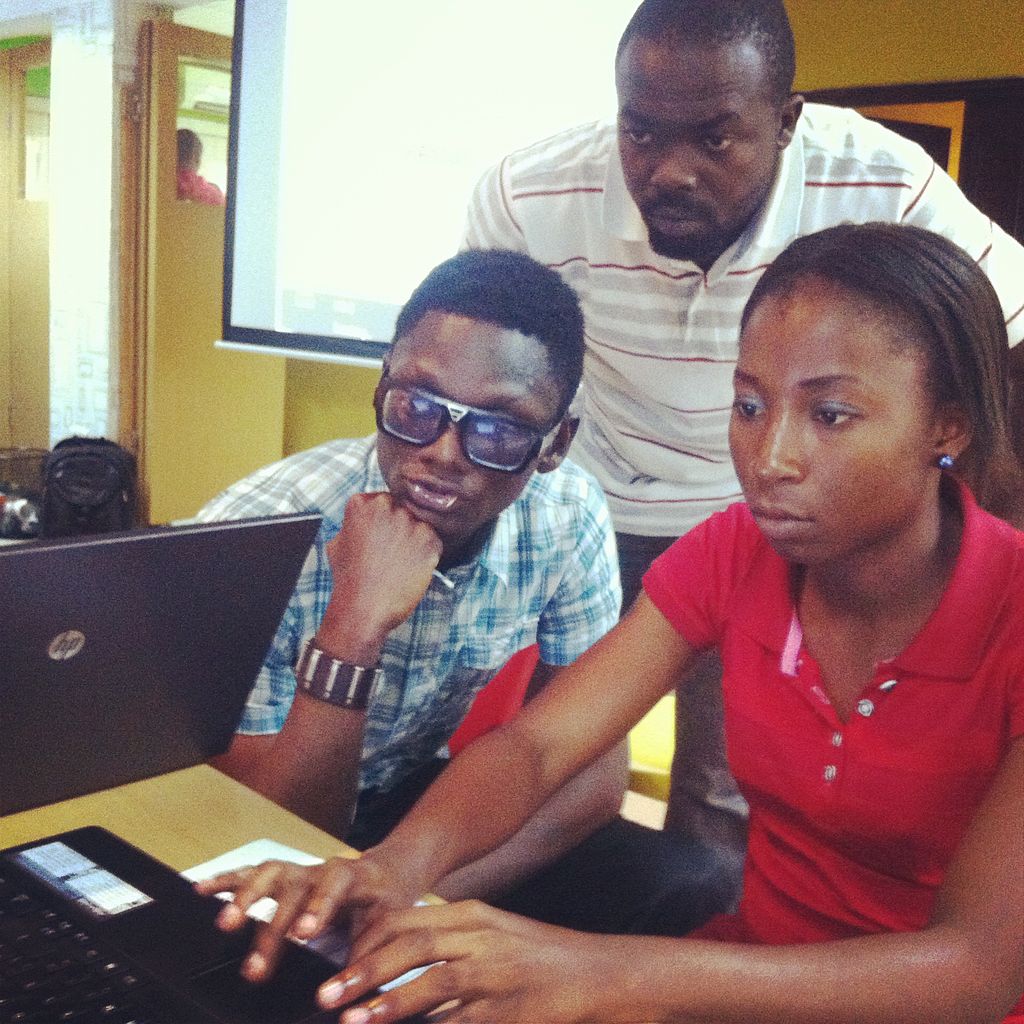
Three young 'hackers' at the Co-Creation Hub in Lagos, busy at work trying to turn complex trade and development data into easy-to-understand web sites, visualisations and mobile applications. The Department for International Development's Trade Policy team recently ran a pilot project called the DFID Data Challenge 2012 Trade Transparency Initiative, involving the Co-Creation Hub in Nigeria, a similar 'social innovation' centre called R-Labs in Capetown, and the London-based Re-Wired State organisation. Teams of web and software developers, designers and analysts in each location volunteered their time for two days, were given the same sets of trade and development data, and challenged to come up with innovative ideas to help explain that complex data to the public. The project aimed to explore the relationship between trade tariffs on basic goods in different countries and the retail prices of those goods on the street. The results of the 'trade hacks' can be seen on the Rewired State website at hacks.rewiredstate.org/events/dfiddc2012, and some of them will be profiled at Open Up!, a conference that DFID is hosting with Omidyar Network and Wired Magazine in London on 13 November, bringing technology, innovation and open government together. Picture: Russell Watkins/Department for International Development Terms of use This image is posted under a Creative Commons - Attribution Licence, in accordance with the Open Government Licence. You are free to embed, download or otherwise re-use it, as long as you credit the source as Russell Watkins/Department for International Development'. |
| Date | |
| Source | Opening up DFID's trade data in downtown Lagos |
| Author | DFID - UK Department for International Development |
| Camera location | | View this and other nearby images on: OpenStreetMap |
|---|
.jpg¶ms=006.504480_N_0003.377898_E_globe:Earth_type:camera_source:Flickr_&language=en)
Licensing edit
.jpg&action=edit§ion=2)
- You are free:
- to share – to copy, distribute and transmit the work
- to remix – to adapt the work
- Under the following conditions:
- attribution – You must give appropriate credit, provide a link to the license, and indicate if changes were made. You may do so in any reasonable manner, but not in any way that suggests the licensor endorses you or your use.
| This image, originally posted to Flickr, was reviewed on 22 May 2013 by the administrator or reviewer File Upload Bot (Magnus Manske), who confirmed that it was available on Flickr under the stated license on that date. |
File history
Click on a date/time to view the file as it appeared at that time.
| Date/Time | Thumbnail | Dimensions | User | Comment | |
|---|---|---|---|---|---|
| current | 16:42, 22 May 2013 | | 1,936 × 1,936 (1.23 MB) | File Upload Bot (Magnus Manske) (talk | contribs) | Transferred from Flickr by User:russavia |
You cannot overwrite this file.
File usage on Commons
There are no pages that use this file.
.jpg&oldid=853037466)