File:Orca LocationMap.jpg
No higher resolution available.
Orca_LocationMap.jpg (300 × 300 pixels, file size: 11 KB, MIME type: image/jpeg)
Captions
Captions
Add a one-line explanation of what this file represents
Summary edit
| Description |
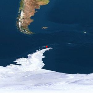
English: Location of Orca Seamount |
| Date | 2/5/09 autogenerated map |
| Source | [1] |
| Author | www.geody.com, satellite mapping |
| Permission (Reusing this file) |
According to this licensing page, it is under Creative Commons Attribute 2.5 |
![[1]](http://www.geody.com/locmapin.jpg.php?world=terra&map=col&lat=-62.433334&lon=-58.400002&spot=1)
Licensing edit
This file is licensed under the Creative Commons Attribution 2.5 Generic license.
- You are free:
- to share – to copy, distribute and transmit the work
- to remix – to adapt the work
- Under the following conditions:
- attribution – You must give appropriate credit, provide a link to the license, and indicate if changes were made. You may do so in any reasonable manner, but not in any way that suggests the licensor endorses you or your use.
File history
Click on a date/time to view the file as it appeared at that time.
| Date/Time | Thumbnail | Dimensions | User | Comment | |
|---|---|---|---|---|---|
| current | 21:11, 5 February 2009 | | 300 × 300 (11 KB) | Resident Mario (talk | contribs) | {{Information |Description = Location of Orca Seamount |Source = [http://www.geody.com/locmapin.jpg.php?world=terra&map=col&lat=-62.433334&lon=-58.400002&spot=1] |Date = 2/5/09 autogenerated map |Author = www.geody.com, satellite mapping |Permission = Acc |
You cannot overwrite this file.
File usage on Commons
There are no pages that use this file.
File usage on other wikis
The following other wikis use this file:
- Usage on en.wikipedia.org