File:Ordnance Survey Drawings - Bovey Tracey (OSD 37).jpg

Size of this preview: 783 × 599 pixels. Other resolutions: 314 × 240 pixels | 627 × 480 pixels | 1,003 × 768 pixels | 1,280 × 980 pixels | 2,560 × 1,960 pixels | 4,000 × 3,062 pixels.
Original file (4,000 × 3,062 pixels, file size: 3.72 MB, MIME type: image/jpeg)
Captions
Captions
Add a one-line explanation of what this file represents
| Bovey Tracey (OSD 37)
|
|||||
|---|---|---|---|---|---|
| Artist |
[Hewitt, John] - Draughtsman |
.jpg) | |||
| Title |
Ordnance Survey Drawings: Bovey Tracey (OSD 37) |
||||
| Object type |
manuscript map |
||||
| Description |
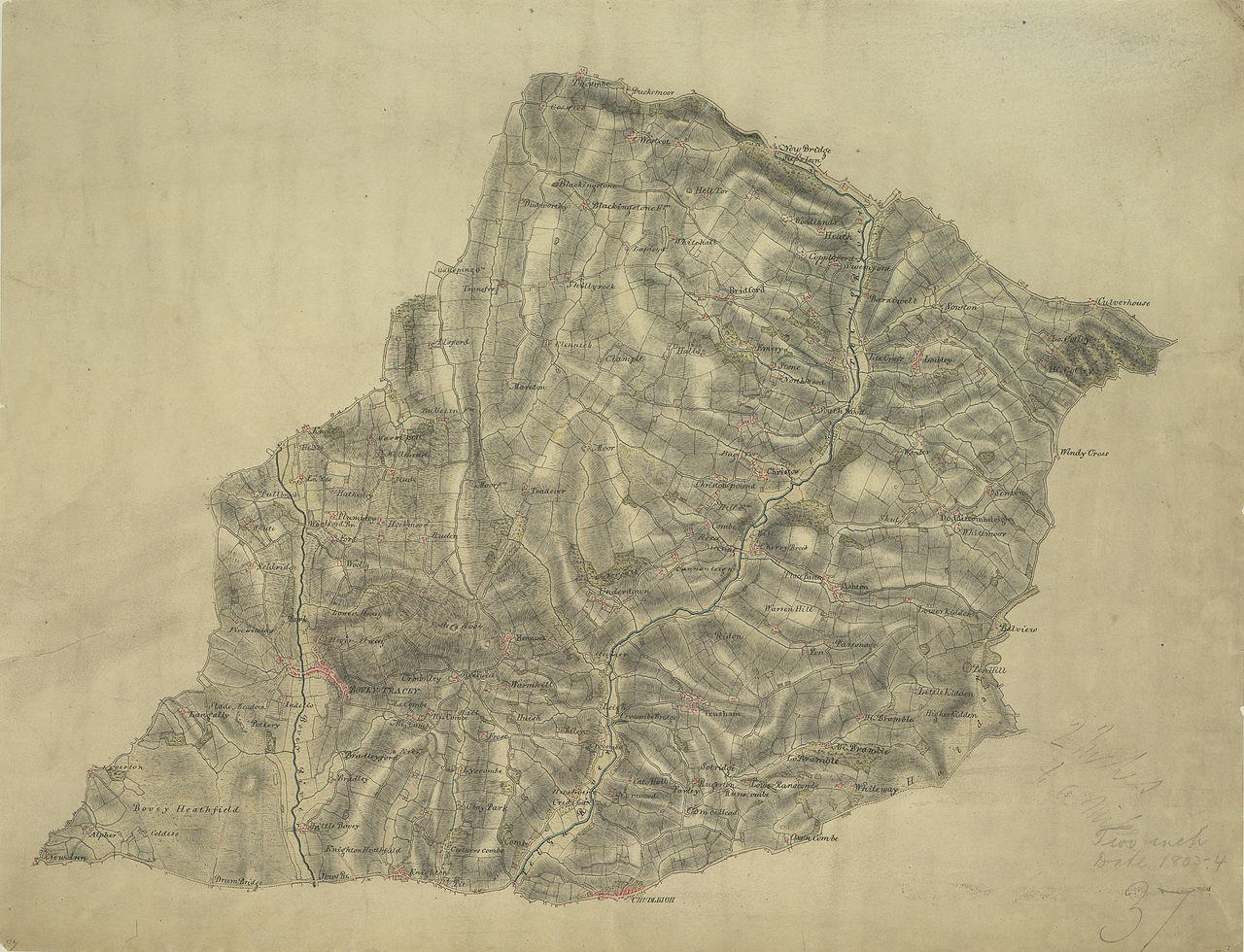
 Centre of map shown on a map of England
English: The military impetus of the Ordnance Survey is evident in the draughtsmen's preoccupation in detailing the lie of the land, not just its topographical features. Relief is indicated here by shading and the use of short disconnected lines drawn in the direction of the slopes - a technique called hachuring. Woods are coloured green. Red crosses and dots around the outer edge of the landmass indicate observation stations, which were used to plot distinctive features of the land being surveyed. The main roads are marked at mile intervals..
This image has been georeferenced.
|
||||
| Language |
English |
||||
| Date | 1803 | ||||
| Medium | Pen and ink on paper | ||||
| Dimensions | height: 190 mm (7.48 in); width: 240 mm (9.44 in) | ||||
| Collection | |||||
| Accession number |
Maps OSD 37 |
||||
| Credit line | British Library | ||||
| Notes |
Scale 2 inches : 1 mile ( 1: 31680). Please note that the British Library provides these digital files "as-is"; materials will not be rephotographed under this programme. If resupply of files is required, the requestor will be required to purchase them at the standard rate. |
||||
| References |
http://www.bl.uk/onlinegallery/onlineex/ordsurvdraw/b/002osd000000001u00030000.html (English) |
||||
| Source/Photographer |
|
||||
| Permission (Reusing this file) |
|
||||


_(St_Edwards_Crown).svg)
.jpg¶ms=50.640143_N_-3.664545_E_)
.jpg¶ms=50.539509_N_-3.818309_E_)
.jpg¶ms=50.740776_N_-3.510782_E_)
.jpg¶ms=50.620456_N_-3.818309_E_)
.jpg¶ms=50.539509_N_-3.673219_E_)
.jpg¶ms=50.659829_N_-3.510782_E_)
.jpg¶ms=50.740776_N_-3.655872_E_)
File history
Click on a date/time to view the file as it appeared at that time.
| Date/Time | Thumbnail | Dimensions | User | Comment | |
|---|---|---|---|---|---|
| current | 21:26, 26 September 2013 | | 4,000 × 3,062 (3.72 MB) | LibraryBot (talk | contribs) | {{subst:User:Andrew Gray/OSD|ID= 002OSD000000001U00030000 |OSD_NUM= OSD 37 |MEDIUM= Pen and ink on paper |TITLE= Bovey Tracey |CREATOR= [Hewitt, John] - Draughtsman |YEAR= 1803 |DESCRIPTION= The military impetus of the Ordnance Survey is evident in the... |
You cannot overwrite this file.
File usage on Commons
The following page uses this file:
File usage on other wikis
The following other wikis use this file:
- Usage on www.wikidata.org
.jpg&oldid=688969062)