File:Ordnance Survey Drawings - Cleobury Mortimer, Shropshire (OSD 206).jpg
Size of this preview: 800 × 577 pixels. Other resolutions: 320 × 231 pixels | 640 × 461 pixels | 1,024 × 738 pixels | 1,280 × 923 pixels | 2,560 × 1,846 pixels | 5,586 × 4,027 pixels.
Original file (5,586 × 4,027 pixels, file size: 4.64 MB, MIME type: image/jpeg)
Captions
Captions
Add a one-line explanation of what this file represents
| Cleobury Mortimer (OSD 206)
|
|||||
|---|---|---|---|---|---|
| Artist |
Stevens, Henry - Draughtsman |
.jpg) | |||
| Title |
Ordnance Survey Drawings: Cleobury Mortimer, Shropshire (OSD 206) |
||||
| Object type |
manuscript map |
||||
| Description |
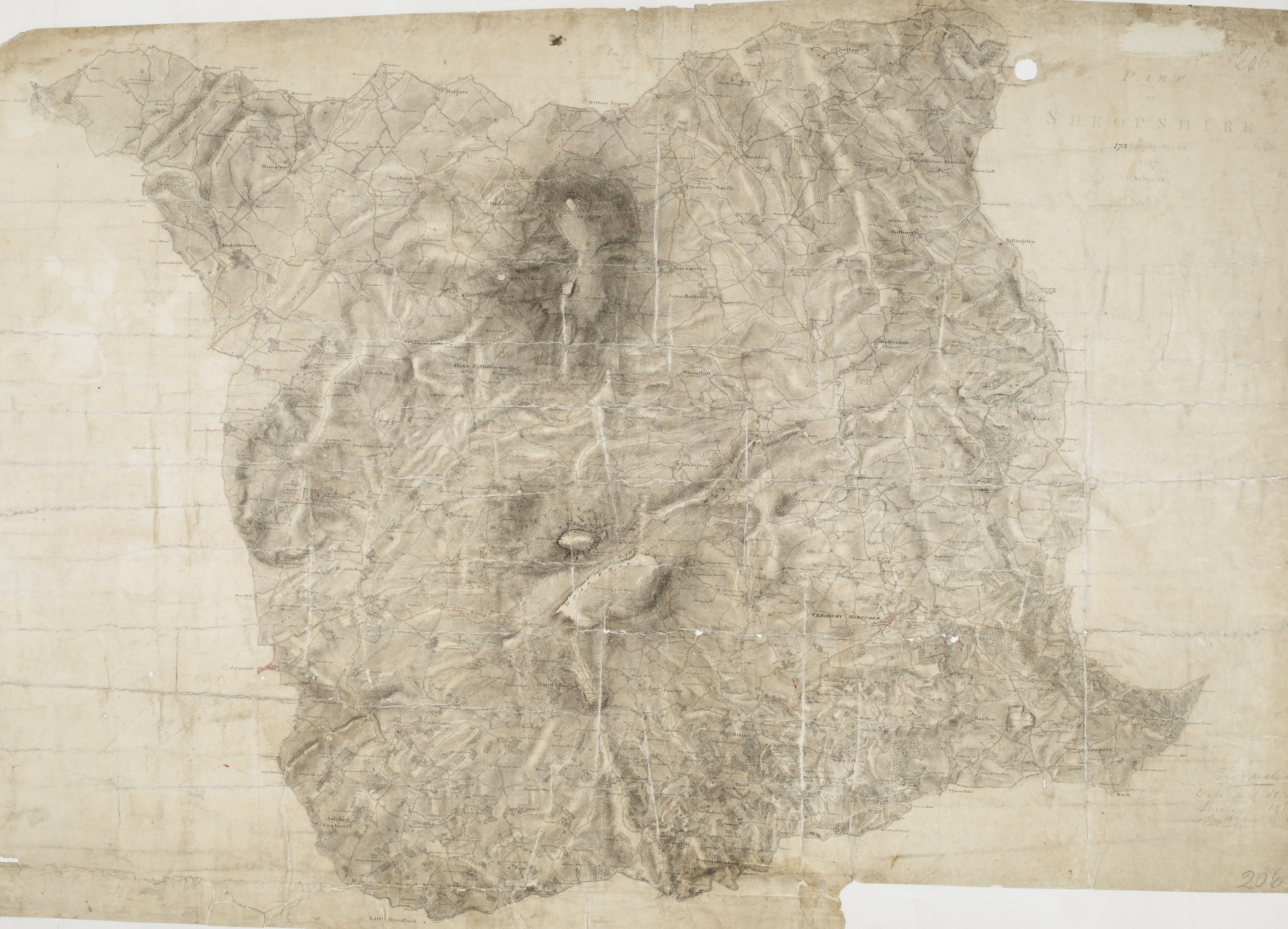
 Centre of map shown on a map of England
English: The two smooth humps of Brown Clee Hill dominate the landscape east of Ludlow. With its summit rising to 1,772 ft, Brown Clee is the highest point in Shropshire and was,an iron-age settlement, hosting three hillforts.,Below Brown Clee, the plan shows another isolated hill fort at Titterstone Clee.,At an altitude of,1,750 ft,,this fort is one of the highest and largest in Britain. ,.
This image has been georeferenced.
|
||||
| Language |
English |
||||
| Date | 1817 | ||||
| Medium | Pen and ink on paper | ||||
| Dimensions | height: 320 mm (12.59 in); width: 450 mm (17.71 in) | ||||
| Collection | |||||
| Accession number |
Maps OSD 206 |
||||
| Credit line | British Library | ||||
| Notes |
Scale 2 inches : 1 mile (1:31680). Please note that the British Library provides these digital files "as-is"; materials will not be rephotographed under this programme. If resupply of files is required, the requestor will be required to purchase them at the standard rate. |
||||
| References |
http://www.bl.uk/onlinegallery/onlineex/ordsurvdraw/c/002osd000000022u00165000.html (English) |
||||
| Source/Photographer |
|
||||
| Permission (Reusing this file) |
|
||||


.svg)
.jpg¶ms=52.415189_N_-2.571312_E_)
.jpg¶ms=52.307559_N_-2.816801_E_)
.jpg¶ms=52.522819_N_-2.325823_E_)
.jpg¶ms=52.522819_N_-2.813569_E_)
.jpg¶ms=52.308774_N_-2.816801_E_)
.jpg¶ms=52.307559_N_-2.329055_E_)
.jpg¶ms=52.521604_N_-2.325823_E_)
File history
Click on a date/time to view the file as it appeared at that time.
| Date/Time | Thumbnail | Dimensions | User | Comment | |
|---|---|---|---|---|---|
| current | 09:22, 26 September 2013 | | 5,586 × 4,027 (4.64 MB) | LibraryBot (talk | contribs) | {{subst:User:Andrew Gray/OSD|ID= 002OSD000000022U00165000 |OSD_NUM= OSD 206 |MEDIUM= Pen and ink on paper |TITLE= Cleobury Mortimer, Shropshire |CREATOR= Stevens, Henry - Draughtsman |YEAR= 1817 |DESCRIPTION= The two smooth humps of Brown Clee Hill dom... |
You cannot overwrite this file.
File usage on Commons
The following page uses this file:
File usage on other wikis
The following other wikis use this file:
- Usage on www.wikidata.org
.jpg&oldid=713432162)