File:Ortelius 1572 Ireland Map 2.jpg
No higher resolution available.
Ortelius_1572_Ireland_Map_2.jpg (693 × 594 pixels, file size: 513 KB, MIME type: image/jpeg)
Captions
Captions
Add a one-line explanation of what this file represents
Summary edit
| Description |
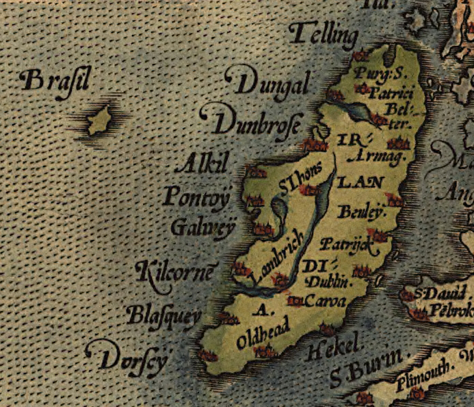
Deutsch: Ausschnitt einer Europakarte Abraham Ortelius’ mit Irland. Westlich ist die Phantominsel Brasil eingezeichnet.
English: Detail of Abraham Ortelius' 1572 map of Europe, depicting Ireland. The phantom island of Brasil is shown to the west. |
|||||||||||||||||||||||
| Date | ||||||||||||||||||||||||
| Source | ||||||||||||||||||||||||
| Author |
|
|||||||||||||||||||||||


| This is a retouched picture, which means that it has been digitally altered from its original version. Modifications: Cropped. Modifications made by Lewenstein.
|
Licensing edit
|
This is a faithful photographic reproduction of a two-dimensional, public domain work of art. The work of art itself is in the public domain for the following reason:
The official position taken by the Wikimedia Foundation is that "faithful reproductions of two-dimensional public domain works of art are public domain".
This photographic reproduction is therefore also considered to be in the public domain in the United States. In other jurisdictions, re-use of this content may be restricted; see Reuse of PD-Art photographs for details. | ||||
File history
Click on a date/time to view the file as it appeared at that time.
| Date/Time | Thumbnail | Dimensions | User | Comment | |
|---|---|---|---|---|---|
| current | 10:39, 19 December 2016 | | 693 × 594 (513 KB) | Lewenstein (talk | contribs) | == {{int:filedesc}} == {{Information |Description={{de|1=Ausschnitt einer Europakarte Abraham Ortelius’ mit Irland. Westlich davon ist die Phantominsel Brasil verzeichnet.}} |Source={{extracted from|1572 Europa Ortelius.jpg}} |Dat... |
You cannot overwrite this file.
File usage on Commons
The following page uses this file:
File usage on other wikis
The following other wikis use this file:
- Usage on de.wikipedia.org
- Usage on en.wikipedia.org