File:Oshawa (riding map).png

Size of this preview: 500 × 599 pixels. Other resolutions: 200 × 240 pixels | 400 × 480 pixels | 641 × 768 pixels | 1,048 × 1,256 pixels.
Original file (1,048 × 1,256 pixels, file size: 169 KB, MIME type: image/png)
Captions
Captions
Add a one-line explanation of what this file represents
Summary edit
.png&action=edit§ion=1)
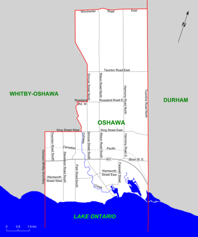
| Description | Map of the Ontario federal and political riding of Oshawa (boundaries defined 2003, adopted federally in 2004 and provincially in 2007) |
| Date | |
| Source | Self-made, based on map at Elections Canada web site |
| Author | Slyguy |
Licensing edit
.png&action=edit§ion=2)
| I, the copyright holder of this work, release this work into the public domain. This applies worldwide. In some countries this may not be legally possible; if so: I grant anyone the right to use this work for any purpose, without any conditions, unless such conditions are required by law. |
File history
Click on a date/time to view the file as it appeared at that time.
| Date/Time | Thumbnail | Dimensions | User | Comment | |
|---|---|---|---|---|---|
| current | 20:03, 29 January 2008 | | 1,048 × 1,256 (169 KB) | Slyguy~commonswiki (talk | contribs) | {{Information |Description=Map of the Ontario federal and political riding of Oshawa (boundaries defined 2003, adopted federally in 2004 and provincially in 2007) |Source=Self-made, based on [http://www.elections.ca/scripts/pss/PopUpWindows.asp?ED=35061 m |
You cannot overwrite this file.
File usage on Commons
There are no pages that use this file.
File usage on other wikis
The following other wikis use this file:
- Usage on en.wikipedia.org
- Usage on fr.wikipedia.org
.png&oldid=456069826)