File:Oxenhope Moor Laboratories - geograph.org.uk - 367955.jpg

Size of this preview: 435 × 600 pixels. Other resolutions: 174 × 240 pixels | 464 × 640 pixels.
Original file (464 × 640 pixels, file size: 106 KB, MIME type: image/jpeg)
Captions
Captions
Add a one-line explanation of what this file represents
Summary edit
| Description |
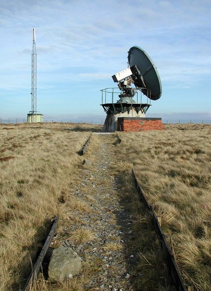
English: Oxenhope Moor Laboratories. The University of Bradford Oxenhope Moor Laboratories at Cock Hill, a former Royal Air Force navigational aid station. Research was carried out here by the university to measure raindrop size for weather forecasting, to measure the apparent brightness of the stars and to monitor the atmospheric absorption of light to predict global warming effects. The installation now appears to be derelict. |
| Date | |
| Source | From geograph.org.uk |
| Author | Paul Glazzard |
| Attribution (required by the license) | Paul Glazzard / Oxenhope Moor Laboratories / |
| Camera location | | View this and other nearby images on: OpenStreetMap |
|---|
_heading:112.00&language=en)
| Object location | | View this and other nearby images on: OpenStreetMap |
|---|
_heading:112.00&language=en)
Licensing edit

|
This image was taken from the Geograph project collection. See this photograph's page on the Geograph website for the photographer's contact details. The copyright on this image is owned by Paul Glazzard and is licensed for reuse under the Creative Commons Attribution-ShareAlike 2.0 license.
|
This file is licensed under the Creative Commons Attribution-Share Alike 2.0 Generic license.
Attribution: Paul Glazzard
- You are free:
- to share – to copy, distribute and transmit the work
- to remix – to adapt the work
- Under the following conditions:
- attribution – You must give appropriate credit, provide a link to the license, and indicate if changes were made. You may do so in any reasonable manner, but not in any way that suggests the licensor endorses you or your use.
- share alike – If you remix, transform, or build upon the material, you must distribute your contributions under the same or compatible license as the original.
File history
Click on a date/time to view the file as it appeared at that time.
| Date/Time | Thumbnail | Dimensions | User | Comment | |
|---|---|---|---|---|---|
| current | 17:41, 4 January 2011 | | 464 × 640 (106 KB) | GeographBot (talk | contribs) | == {{int:filedesc}} == {{Information |description={{en|1=Oxenhope Moor Laboratories The University of Bradford Oxenhope Moor Laboratories at Cock Hill, a former Royal Air Force navigational aid station. Research was carried out here by the university to m |
You cannot overwrite this file.
File usage on Commons
There are no pages that use this file.