File:PIA01400 The Galilean Satellites (without borders).jpg

Original file (1,886 × 575 pixels, file size: 113 KB, MIME type: image/jpeg)
Captions
Captions
Summary edit
.jpg&action=edit§ion=1)
| Description |
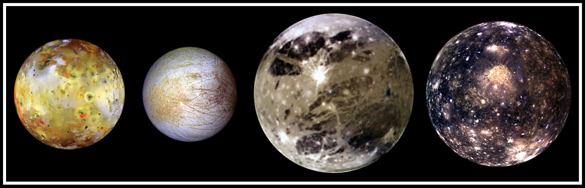
English: In this "family portrait," the four Galilean Satellites are shown to scale. These four largest moons of Jupiter shown in increasing distance from Jupiter are (left to right) Io, Europa, Ganymede, and Callisto.
These global views show the side of volcanically active Io which always faces away from Jupiter, icy Europa, the Jupiter-facing side of Ganymede, and heavily cratered Callisto. The appearances of these neighboring satellites are amazingly different even though they are relatively close to Jupiter (350,000 kilometers for Io; 1, 800,000 kilometers for Callisto). These images were acquired on several orbits at very low "phase" angles (the sun, spacecraft, moon angle) so that the sun is illuminating the Jovian moons from completely behind the spacecraft, in the same way a full moon is viewed from Earth. The colors have been enhanced to bring out subtle color variations of surface features. North is to the top of all the images which were taken by the Solid State Imaging (SSI) system on NASA's Galileo spacecraft. Io, which is slightly larger than Earth's moon, is the most colorful of the Galilean satellites. Its surface is covered by deposits from actively erupting volcanoes, hundreds of lava flows, and volcanic vents which are visible as small dark spots. Several of these volcanoes are very hot; at least one reached a temperature of 2000 degrees Celsius (3600 degrees Fahrenheit) in the summer of 1997. Prometheus, a volcano located slightly right of center on Io's image, was active during the Voyager flybys in 1979 and is still active as Galileo images were obtained. This global view was obtained in September 1996 when Galileo was 485,000 kilometers from Io; the finest details that can be discerned are about 10 km across. The bright, yellowish and white materials located at equatorial latitudes are believed to be composed of sulfur and sulfur dioxide. The polar caps are darker and covered by a redder material. Europa has a very different surface from its rocky neighbor, Io. Galileo images hint at the possibility of liquid water beneath the icy crust of this moon. The bright white and bluish parts of Europa's surface are composed almost completely of water ice. In contrast, the brownish mottled regions on the right side of the image may be covered by salts (such as hydrated magnesium-sulfate) and an unknown red component. The yellowish mottled terrain on the left side of the image is caused by some other, unknown contaminant. This global view was obtained in June 1997 when Galileo was 1.25 million kilometers from Europa; the finest details that can be discerned are 25 kilometers across. Ganymede, larger than the planet Mercury, is the largest Jovian satellite. Its distinctive surface is characterized by patches of dark and light terrain. Bright frost is visible at the north and south poles. The very bright icy impact crater, Tros, is near the center of the image in a region known as Phrygia Sulcus. The dark area to the northwest of Tros is Perrine Regio; the dark terrain to the south and southeast is Nicholson Regio. Ganymede's surface is characterized by a high degree of crustal deformation. Much of the surface is covered by water ice, with a higher amount of rocky material in the darker areas. This global view was taken in September 1997 when Galileo was 1.68 million kilometers from Ganymede; the finest details that can be discerned are about 67 kilometers across. Callisto's dark surface is pocked by numerous bright impact craters. The large Valhalla multi-ring structure (visible near the center of the image) has a diameter of about 4,000 kilometers, making it one of the largest impact features in the Solar System. Although many crater rims exhibit bright icy "bedrock" material, a dark layer composed of hydrated minerals and organic components (tholins) is seen inside many craters and in other low lying areas. Evidence of tectonic and volcanic activity, seen on the other Galilean satellites, appears to be absent on Callisto. This global view was obtained in November 1997 when Galileo was 684,500 kilometers from Callisto; the finest details that can be discerned are about 27 kilometers across. |
| Date | |
| Source | http://photojournal.jpl.nasa.gov/catalog/PIA01400 (image link) |
| Author | NASA/JPL/DLR |
This image or video was catalogued by Jet Propulsion Laboratory of the United States National Aeronautics and Space Administration (NASA) under Photo ID: PIA01400. This tag does not indicate the copyright status of the attached work. A normal copyright tag is still required. See Commons:Licensing. Other languages:
|
Licensing edit
.jpg&action=edit§ion=2)
| This file is in the public domain in the United States because it was solely created by NASA. NASA copyright policy states that "NASA material is not protected by copyright unless noted". (See Template:PD-USGov, NASA copyright policy page or JPL Image Use Policy.) | ||
 |
Warnings:
|
File history
Click on a date/time to view the file as it appeared at that time.
| Date/Time | Thumbnail | Dimensions | User | Comment | |
|---|---|---|---|---|---|
| current | 02:38, 25 April 2015 | 1,886 × 575 (113 KB) | Jcpag2012 (talk | contribs) | Cropped version of File:PIA01400 The Galilean Satellites.jpg using CropTool. |
You cannot overwrite this file.
File usage on Commons
The following page uses this file:
.jpg&oldid=441705341)