File:PIA12291 - Bedrock Exhumed from the Deep.jpg

Original file (4,500 × 3,000 pixels, file size: 2.06 MB, MIME type: image/jpeg)
Captions
Captions
Summary
edit
| Description |
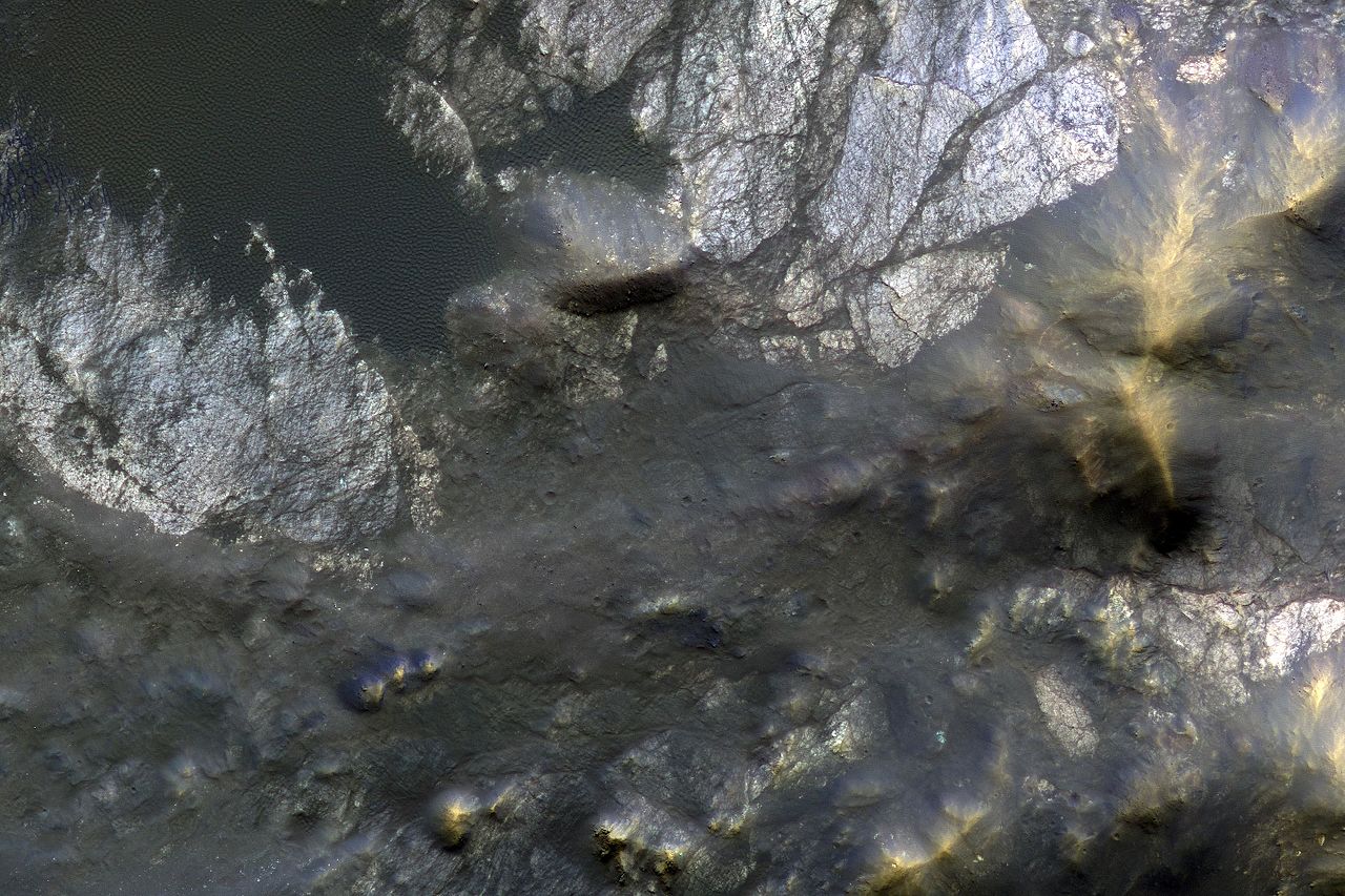
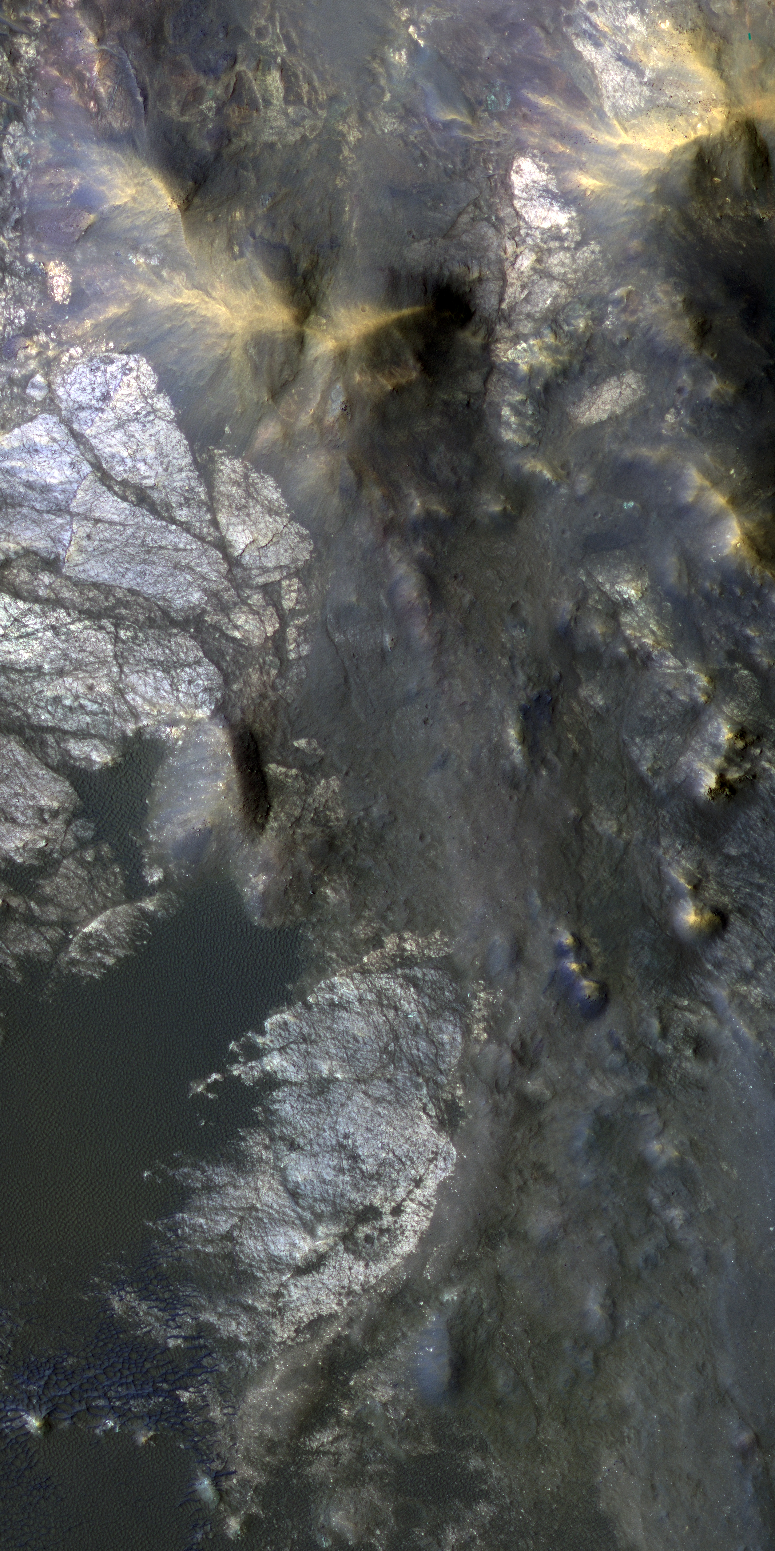
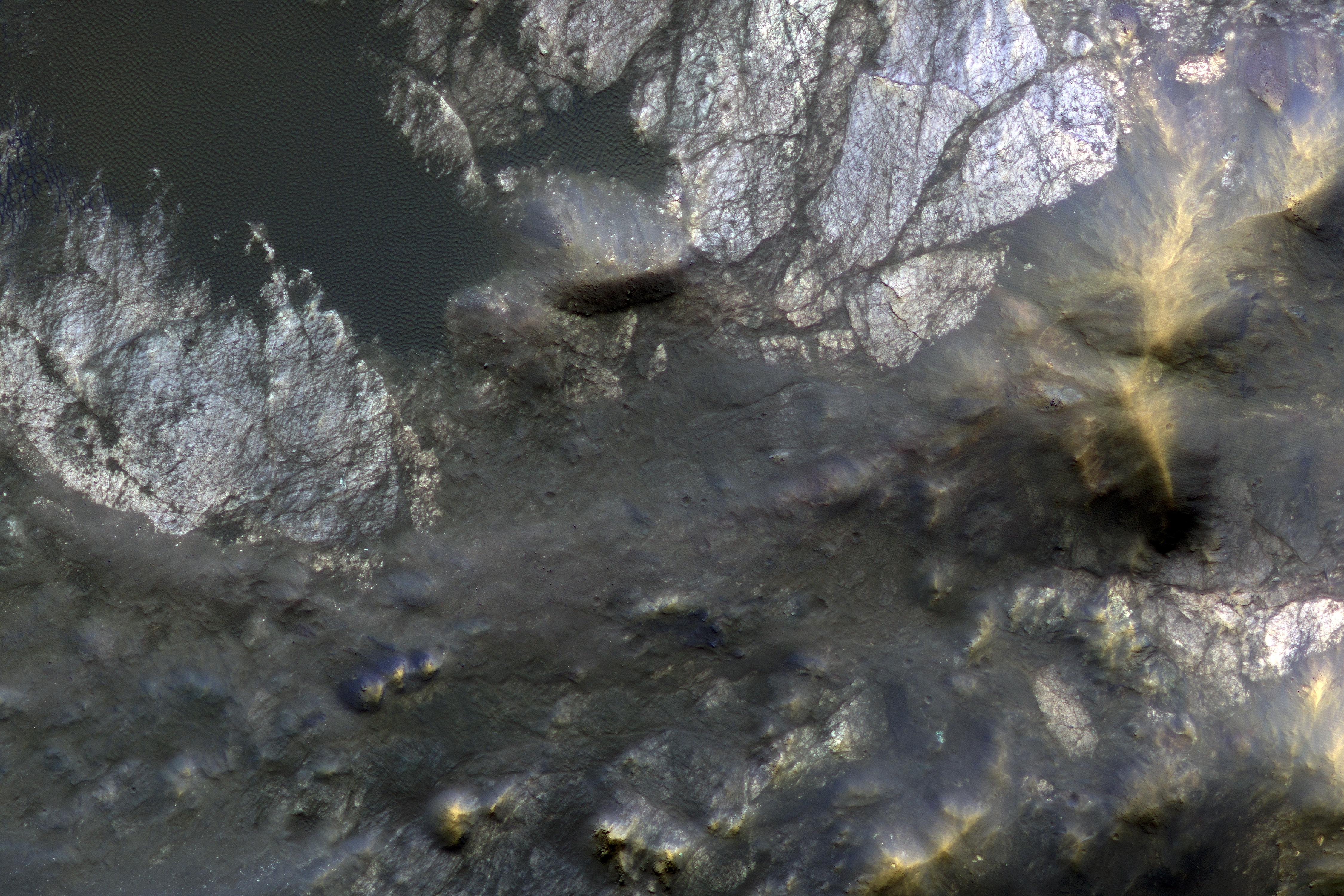
English: Roadside bedrock outcrops are all too familiar for many who have taken a long road trip through mountainous areas on Earth. Martian craters provide what tectonic mountain building and man's TNT cannot: crater-exposed bedrock outcrops.
Although crater and valley walls offer us roadside-like outcrops from just below the Martian surface, their geometry is not always conducive to orbital views. On the other hand, a crater central peak -- a collection of mountainous rocks that have been brought up from depth, but also rotated and jumbled during the cratering process -- produce some of the most spectacular views of bedrock from orbit. This color composite cutout shows an example of such bedrock that may originate from as deep as 2 miles beneath the surface. The bedrock at this scale is does not appear to be layered or made up of grains, but has a massive appearance riddled with cross-cutting fractures, some of which have been filled by dark materials and rock fragments (impact melt and breccias) generated by the impact event. A close inspection of the image shows that these light-toned bedrock blocks are partially to fully covered by sand dunes and coated with impact melt bearing breccia flows. This is a stereo pair with ESP_012367_1695. The University of Arizona, Tucson, operates HiRISE, which was built by Ball Aerospace & Technologies Corp., Boulder, Colo. NASA's Jet Propulsion Laboratory, a division of Caltech in Pasadena, California, manages the Mars Reconnaissance Orbiter Project for NASA's Science Mission Directorate, Washington. |
| Date | 10 January 2009 (published 18 January 2017) |
| Source | Catalog page · Full-res (JPEG · TIFF) |
| Author | NASA/JPL-Caltech/Univ. of Arizona |
| Location on Mars | View this and other nearby images on: Google Maps |
|---|
This image or video was catalogued by Jet Propulsion Laboratory of the United States National Aeronautics and Space Administration (NASA) under Photo ID: PIA12291. This tag does not indicate the copyright status of the attached work. A normal copyright tag is still required. See Commons:Licensing. Other languages:
|
 |
This media is a product of the Mars Reconnaissance Orbiter mission Credit and attribution belongs to the High Resolution Imaging Science Experiment (HiRISE) team, NASA/JPL-Caltech/Univ. of Arizona |
Licensing
edit
| This file is in the public domain in the United States because it was solely created by NASA. NASA copyright policy states that "NASA material is not protected by copyright unless noted". (See Template:PD-USGov, NASA copyright policy page or JPL Image Use Policy.) | ||
 |
Warnings:
|
File history
Click on a date/time to view the file as it appeared at that time.
| Date/Time | Thumbnail | Dimensions | User | Comment | |
|---|---|---|---|---|---|
| current | 03:10, 19 January 2017 | | 4,500 × 3,000 (2.06 MB) | PhilipTerryGraham (talk | contribs) | User created page with UploadWizard |
You cannot overwrite this file.
File usage on Commons
The following page uses this file: