File:PIA13485 - Eroded Scallops with Layers.jpg

Original file (2,880 × 1,800 pixels, file size: 1.1 MB, MIME type: image/jpeg)
Captions
Captions
Summary
edit
| Description |
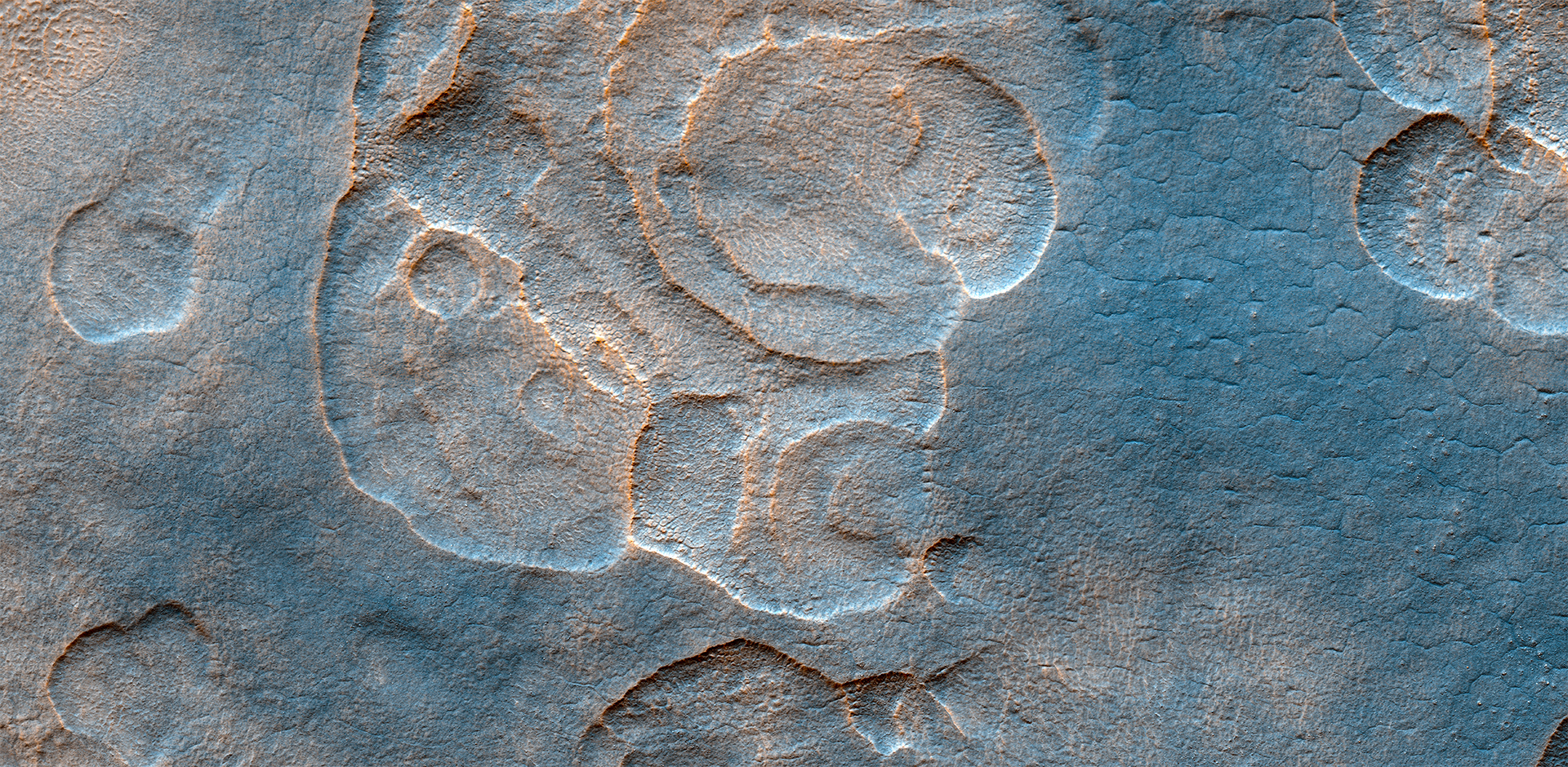
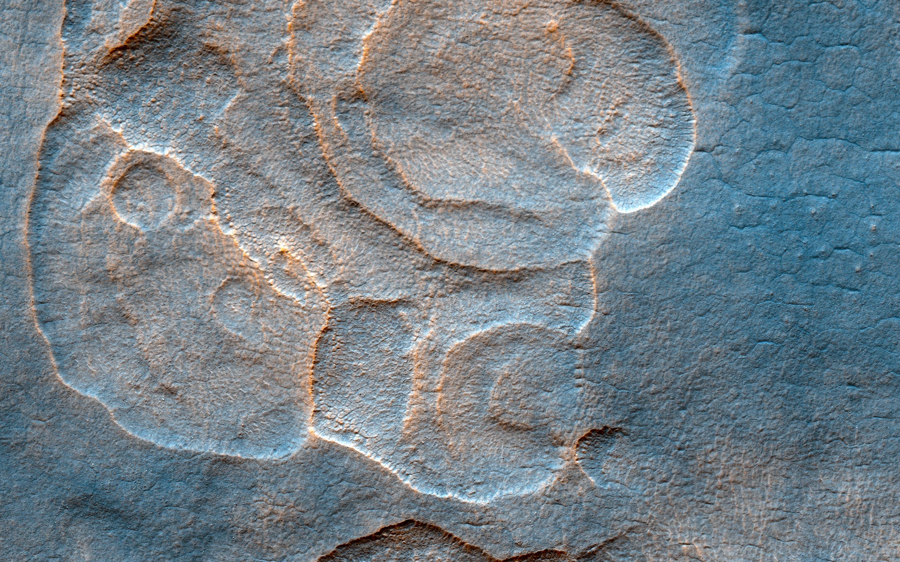
English: The western Utopia Planitia in the Northern mid-latitudes of Mars is marked by a peculiar type of depression with scalloped edges and by a network of polygonal fractures.
The scalloped depressions are typical features; a smooth layered terrain located between 40 and 60 degrees in both hemispheres. Scalloped depressions probably form by removal of ice-rich subsurface material by sublimation (ice transforming directly from a solid to a gaseous state), a process that may still be active today. Isolated scalloped depressions generally have a steep pole-facing scarp and a gentler equator-facing slope. This asymmetry is interpreted as being the result of difference in solar heating. Scalloped depressions may coalesce, leading to the formation of large areas of pitted terrain. The polygonal pattern of fractures resembles permafrost polygons that form in terrestrial polar and high alpine regions by seasonal-to-annual contraction of the permafrost (permanently frozen ground). On Earth, such polygons indicate the presence of ground ice. These landforms most likely show that sub-surface ice is present or has been present geologically recently at these latitudes, and they may slowly be continuing their development at the present time. This is a stereo pair with PSP_002439_2265. The University of Arizona, Tucson, operates HiRISE, which was built by Ball Aerospace & Technologies Corp., Boulder, Colo. NASA's Jet Propulsion Laboratory, a division of Caltech in Pasadena, California, manages the Mars Reconnaissance Orbiter Project for NASA's Science Mission Directorate, Washington. |
| Date | 25 December 2006 (published 9 January 2017) |
| Source | Catalog page · Full-res (JPEG · TIFF) |
| Author | NASA/JPL-Caltech/Univ. of Arizona |
| Location on Mars | View this and other nearby images on: Google Maps |
|---|
This image or video was catalogued by Jet Propulsion Laboratory of the United States National Aeronautics and Space Administration (NASA) under Photo ID: PIA13485. This tag does not indicate the copyright status of the attached work. A normal copyright tag is still required. See Commons:Licensing. Other languages:
|
 |
This media is a product of the Mars Reconnaissance Orbiter mission Credit and attribution belongs to the High Resolution Imaging Science Experiment (HiRISE) team, NASA/JPL-Caltech/Univ. of Arizona |
Licensing
edit
| This file is in the public domain in the United States because it was solely created by NASA. NASA copyright policy states that "NASA material is not protected by copyright unless noted". (See Template:PD-USGov, NASA copyright policy page or JPL Image Use Policy.) | ||
 |
Warnings:
|
File history
Click on a date/time to view the file as it appeared at that time.
| Date/Time | Thumbnail | Dimensions | User | Comment | |
|---|---|---|---|---|---|
| current | 22:06, 12 January 2017 | | 2,880 × 1,800 (1.1 MB) | PhilipTerryGraham (talk | contribs) | User created page with UploadWizard |
You cannot overwrite this file.
File usage on Commons
The following page uses this file:
File usage on other wikis
The following other wikis use this file:
- Usage on es.wikipedia.org