File:PIA17766 Curiosity Mars Rover Approaches 'Dingo Gap,' Mastcam View, Figure 1.jpg

Original file (5,536 × 1,047 pixels, file size: 4.96 MB, MIME type: image/jpeg)
Captions
Captions
Summary edit
| Description |
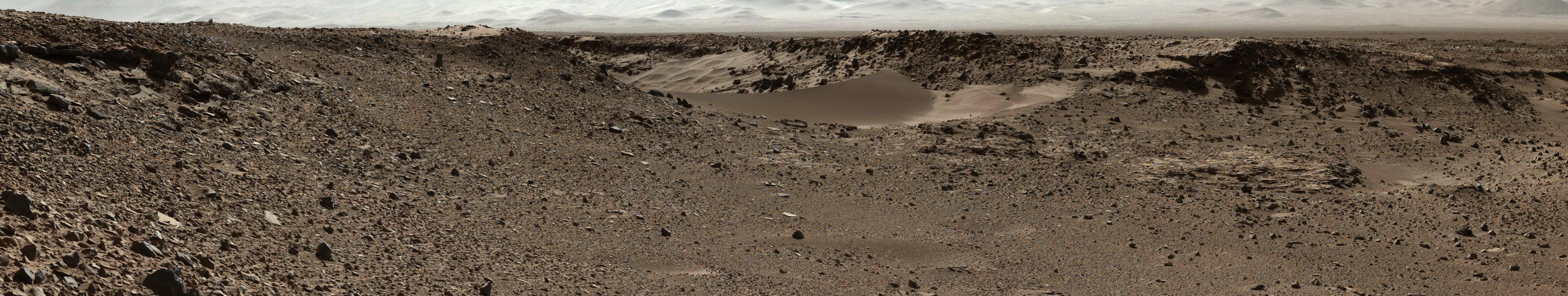
English: This scene combines images taken by the left-eye camera of the Mast Camera (Mastcam) instrument on NASA's Curiosity Mars rover during the midafternoon, local Mars solar time, of the mission's 526th Martian day, or sol (Jan. 28, 2014). The sand dune in the upper center of the image spans a gap, called "Dingo Gap," between two short scarps. The dune is about 3 feet (1 meter) high. The nearer edge of it is about 115 feet (35 meters) away from the rover's position when the component images were taken, just after a Sol 526 drive of 49 feet (15 meters).
The image has been white-balanced to show what the rocks would look like if they were on Earth. A version with 200-centimeter (79-inch) scale bars is available as Figure A. A version with raw color, as recorded by the camera under Martian lighting conditions, is available as Figure B. NASA's Jet Propulsion Laboratory manages the Mars Science Laboratory mission and the mission's Curiosity rover for NASA's Science Mission Directorate in Washington. The rover was designed, developed and assembled at JPL, a division of the California Institute of Technology in Pasadena. Malin Space Science Systems, San Diego, built and operates Mastcam. More information about Curiosity is online at http://www.nasa.gov/msl and http://mars.jpl.nasa.gov/msl/.Polski: Zdjęcie to jest efektem połączenia serii zdjęć wykonanych przez aparat będący lewym okiem kamer masztowych, należącego do NASA łazika Curiosity, popołudniu według lokalnego czasu, w 526 marsjańskim dniu misji, (28 stycznia 2014 r). Piaszczysta wydma znajdująca się u góry w centrum obrazu, nazwana "Dingo Gap", została zawarta pomiędzy dwiema niewysokimi skarpami. Wydma jest wysoka na 1 metr. Bliższa krawędź wydmy jest oddalona około 35 metrów od miejsca znajdowania się łazika podczas gdy elementy składowe zdjęcia były realizowane, zaraz po zakończeniu etapu w 526 Sol wynoszącym 15 metrów. Zdjęcie było poddane regulacji równowagi bieli w taki sposób, aby odzwierciadlało ono wygląd skał, jak gdyby były one oświetlone w warunkach ziemskich. |
| Date | (published 29 January 2014) |
| Source | Catalog page · Full-res (JPEG · TIFF) |
| Author | NASA/JPL-Caltech/MSSS |
| Other versions |
|
| Location on Mars | View this and other nearby images on: Google Maps |
|---|
This image or video was catalogued by Jet Propulsion Laboratory of the United States National Aeronautics and Space Administration (NASA) under Photo ID: PIA17766. This tag does not indicate the copyright status of the attached work. A normal copyright tag is still required. See Commons:Licensing. Other languages:
|
| This media is a product of the Mars Science Laboratory mission Credit and attribution belongs to the Curiosity rover Mast Camera (Mastcam) team, NASA/JPL-Caltech/MSSS |
Licensing edit
| This file is in the public domain in the United States because it was solely created by NASA. NASA copyright policy states that "NASA material is not protected by copyright unless noted". (See Template:PD-USGov, NASA copyright policy page or JPL Image Use Policy.) | ||
 |
Warnings:
|
File history
Click on a date/time to view the file as it appeared at that time.
| Date/Time | Thumbnail | Dimensions | User | Comment | |
|---|---|---|---|---|---|
| current | 17:24, 3 February 2014 | 5,536 × 1,047 (4.96 MB) | Drbogdan (talk | contribs) | User created page with UploadWizard |
You cannot overwrite this file.
File usage on Commons
The following 3 pages use this file:
File usage on other wikis
The following other wikis use this file:
- Usage on fr.wikipedia.org
- Usage on uk.wikipedia.org