File:PIA18392-MarsCuriosityRover-TraverseMap-Context-Sol0663-20140618.jpg

Original file (3,300 × 2,550 pixels, file size: 1.39 MB, MIME type: image/jpeg)
Captions
Captions
Summary edit
| Description |
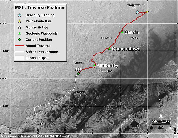
English: Curiosity's Progress on Route to Mount Sharp
June 18, 2014 BASIC http://www.nasa.gov/sites/default/files/pia18391_sol663map-full.jpg DETAILED http://www.nasa.gov/sites/default/files/pia18392_sol663map-large.jpg BASIC A major destination for the mission remains geological layering exposed on the lower slope of Mount Sharp, with "Murray Buttes" chosen as the entry point because of a gap there in a band of dark-toned dune fields edging the base of the mountain. The white line indicates a planned route to Murray Buttes chosen in spring 2014 as the safest path for the rover's wheels. Embedded, sharp rocks on the route driven between the "Cooperstown" and "Kimberley" waypoints marked on the map caused the pace of wear and tear on the wheels to accelerate unexpectedly in late 2013. The white-line route avoids some stretches of similar terrain on a more northerly route previously planned for getting to Murray Buttes. The base image for this map is from the High Resolution Imaging Science Experiment (HiRISE) camera on NASA's Mars Reconnaissance Orbiter. North is up. The scale bar at lower right represents one kilometer (0.62 mile). For broader-context images of the area, see PIA16064 => http://photojournal.jpl.nasa.gov/catalog/PIA16064 and PIA16058 => http://photojournal.jpl.nasa.gov/catalog/PIA16058. At Yellowknife Bay, the Mars Science Laboratory Project that built and operates Curiosity achieved its main science objective of determining whether Mars ever offered environmental conditions favorable for microbial life. Rock-powder samples drilled from two mudstone rocks there and analyzed onboard yielded evidence for an ancient lakebed with mild water, the chemical elements needed for life and a mineral source of energy used by some Earth microbes. NASA's Jet Propulsion Laboratory, a division of the California Institute of Technology, Pasadena, manages the Mars Science Laboratory Project and Mars Reconnaissance Orbiter Project for NASA's Science Mission Directorate, Washington. DETAILED This map shows in red the route driven by NASA's Curiosity Mars rover from the "Bradbury Landing" location where it touched down in August 2012 (blue star at upper right) through the 663rd Martian day, or sol, of the rover's work on Mars (June 18, 2014). The white line shows the planned route ahead to reach "Murray Buttes" (at white star), the chosen access point to destinations on Mount Sharp. The rover will complete a mission goal of working for a full Martian year on Sol 669 (June 24, 2014). A Martian year is 687 Earth days. Gridlines indicate quadrants charted before the rover's landing for purposes of geological mapping of the landing region within Mars' Gale Crater. The Sol 663 location is within the Hanover quadrant. Next on the rover's route is the Shoshone quadrant. The curved line cutting through the northern portion of the Shoshone quadrant is the edge of the mission's target landing ellipse -- the area within which engineers calculated the spacecraft would land. For a wider view that includes the entire ellipse, see PIA15687 => http://photojournal.jpl.nasa.gov/catalog/pia15687 . Curiosity departed a waypoint called "The Kimberley" on Sol 630 (May 15, 2014) and reached the Sol 663 (June 18, 2014) location by driving more than three-fourths of a mile (1.2 kilometers) in five weeks. A major destination for the mission remains geological layering exposed on the lower slope of Mount Sharp, with "Murray Buttes" chosen as the entry point because of a gap there in a band of dark-toned dune fields edging the base of the mountain. The white line indicates a planned route to Murray Buttes chosen in spring 2014 as the safest path for the rover's wheels. Embedded, sharp rocks on the route driven between the "Cooperstown" and "Kimberley" waypoints marked on the map caused the pace of wear and tear on the wheels to accelerate unexpectedly in late 2013. The white-line route avoids some stretches of similar terrain on a more northerly route previously planned for getting to Murray Buttes. The base image for this map is from the High Resolution Imaging Science Experiment (HiRISE) camera on NASA's Mars Reconnaissance Orbiter. North is up. The scale bar at lower right represents one kilometer (0.62 mile). At Yellowknife Bay, the Mars Science Laboratory Project that built and operates Curiosity achieved its main science objective of determining whether Mars ever offered environmental conditions favorable for microbial life. Rock-powder samples drilled from two mudstone rocks there and analyzed onboard yielded evidence for an ancient lakebed with mild water, the chemical elements needed for life and a mineral source of energy used by some Earth microbes. NASA's Jet Propulsion Laboratory, a division of the California Institute of Technology, Pasadena, manages the Mars Science Laboratory Project and Mars Reconnaissance Orbiter Project for NASA's Science Mission Directorate, Washington. |
| Date | |
| Source | http://www.nasa.gov/sites/default/files/pia18392_sol663map-large.jpg |
| Author | NASA/JPL-Caltech/Univ. of Arizona/USGS |
Licensing edit
| This file is in the public domain in the United States because it was solely created by NASA. NASA copyright policy states that "NASA material is not protected by copyright unless noted". (See Template:PD-USGov, NASA copyright policy page or JPL Image Use Policy.) | ||
 |
Warnings:
|
File history
Click on a date/time to view the file as it appeared at that time.
| Date/Time | Thumbnail | Dimensions | User | Comment | |
|---|---|---|---|---|---|
| current | 14:29, 24 June 2014 | | 3,300 × 2,550 (1.39 MB) | Drbogdan (talk | contribs) | User created page with UploadWizard |
You cannot overwrite this file.
File usage on Commons
There are no pages that use this file.