File:PIA22216 – Martian 'Perseverance Valley' in Perspective (Vertical Exaggeration).jpg

Original file (3,741 × 2,519 pixels, file size: 972 KB, MIME type: image/jpeg)
Captions
Captions
Summary edit
| Description |
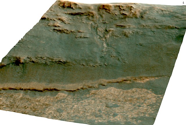
English: The channel descending a Martian slope in this perspective view is "Perseverance Valley," which is the study area of NASA's Mars Exploration Rover Opportunity as the rover passes its 5,000th sol, or Martian day, of its mission on the surface of Mars.
The view was produced by overlaying an image take from orbit onto a topographic model with five-fold vertical exaggeration to emphasize the shapes on the rim of a large crater that have been cut by the valley on the inboard slope of the rim. The image used is from the High Resolution Imaging Science Experiment (HiRISE) camera on NASA's Mars Reconnaissance Orbiter, observation ESP_036753_1775. The crest of a portion of the western rim of Endeavour Crater is at the top of the view, and the floor of the crater is in the foreground, below an erosion-resistant bench perched beneath the valley. The crater is about 14 miles (22 kilometers) in diameter. This perspective view is from within the crater, looking westward. It spans an area about a quarter mile (400 meters) wide from left to right (south to north). The interior rim slopes about 15 to 20 degrees. Figure 1 is an annotated version indicating Perseverance Valley and the bench, plus Opportunity's locations on Sol 5,000 (Feb. 16, 2018) and on Sol 4,958 (Jan. 4, 2018). On Sol 4958, the rover took images with its Navigation Camera and its Hazard Avoidance Camera showing textures of possible stone stripes. The graphic was created at Washington University in St. Louis. A map of a slightly larger portion of the crater rim shows the location of Perseverance Valley and Opportunity's 2017 approach path. As of its Sol 5,000, Opportunity has driven 28 miles (45 kilometers) since its January 2004 landing, in what was planned as a 90-sol mission. NASA's Jet Propulsion Laboratory, a division of the California Institute of Technology in Pasadena, manages the Mars Exploration Rover Project for NASA's Science Mission Directorate, Washington. For more information about Opportunity, visit http://www.nasa.gov/rovers and http://marsrovers.jpl.nasa.gov. |
| Date | 30 May 2014 (published 15 February 2018) |
| Source | Catalog page · Full-res (JPEG · TIFF) |
| Author | NASA/JPL-Caltech/Univ. of Arizona/WUSTL |
| Other versions |
|
.jpg)
,_Figure_1.jpg)
.jpg&action=edit§ion=1)
| Location on Mars | View this and other nearby images on: Google Maps |
|---|
.jpg¶ms=-02.351000_N_-005.348000_E_globe:Mars__&language=en)
This image or video was catalogued by Jet Propulsion Laboratory of the United States National Aeronautics and Space Administration (NASA) under Photo ID: PIA22216. This tag does not indicate the copyright status of the attached work. A normal copyright tag is still required. See Commons:Licensing. Other languages:
|
 |
This media is a product of the Mars Reconnaissance Orbiter mission Credit and attribution belongs to the High Resolution Imaging Science Experiment (HiRISE) team, NASA/JPL-Caltech/Univ. of Arizona |
Licensing edit
.jpg&action=edit§ion=2)
| This file is in the public domain in the United States because it was solely created by NASA. NASA copyright policy states that "NASA material is not protected by copyright unless noted". (See Template:PD-USGov, NASA copyright policy page or JPL Image Use Policy.) | ||
 |
Warnings:
|
File history
Click on a date/time to view the file as it appeared at that time.
| Date/Time | Thumbnail | Dimensions | User | Comment | |
|---|---|---|---|---|---|
| current | 05:32, 16 February 2018 | | 3,741 × 2,519 (972 KB) | PhilipTerryGraham (talk | contribs) | User created page with UploadWizard |
You cannot overwrite this file.
File usage on Commons
The following 2 pages use this file:
.jpg&oldid=287675885)