File:Pakosław (gmina) location map.png
No higher resolution available.
Pakosław_(gmina)_location_map.png (460 × 543 pixels, file size: 50 KB, MIME type: image/png)
Captions
Captions
Add a one-line explanation of what this file represents
| Description |
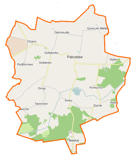
Polski: Mapa gminy Pakosław, Polska
English: Map of Gmina Pakosław, Poland |
|||||||||
| Date | ||||||||||
| Source | You may find a page on the OpenStreetMap wiki page for Pakosław (gmina) | |||||||||
| Creator |
OpenStreetMap contributors OpenStreetMap contributors |
|||||||||
| Permission (Reusing this file) |
OpenStreetMap data is available under the Open Database License (details). Map tiles are licensed under the Creative Commons Attribution-ShareAlike 2.0 license (CC-BY-SA 2.0).
This file is licensed under the Creative Commons Attribution-Share Alike 2.0 Generic license.
|
|||||||||
| Geotemporal data | ||||||||||
| Bounding box |
|
|||||||||
| Georeferencing | If inappropriate please set warp_status = skip to hide. | |||||||||
File history
Click on a date/time to view the file as it appeared at that time.
| Date/Time | Thumbnail | Dimensions | User | Comment | |
|---|---|---|---|---|---|
| current | 22:54, 27 December 2014 | | 460 × 543 (50 KB) | VanWiel (talk | contribs) | {{OpenStreetMap | name = Pakosław (gmina) | location = Pakosław (gmina) | description = {{pl|Mapa gminy Pakosław, Polska}} {{en|Map of Gmina Pakosław, Poland}} | top = 51.6572 | bottom = 51.5414... |
You cannot overwrite this file.
File usage on Commons
There are no pages that use this file.
File usage on other wikis
The following other wikis use this file:
- Usage on fr.wikipedia.org
- Usage on pl.wikipedia.org
- Pakosław (gmina)
- Białykał
- Góreczki Wielkie
- Golejewko
- Kubeczki
- Niedźwiadki (województwo wielkopolskie)
- Ostrobudki
- Podborowo (powiat rawicki)
- Pomocno
- Sworowo
- Sowy (województwo wielkopolskie)
- Zaorle (wieś w województwie wielkopolskim)
- Golejewo (województwo wielkopolskie)
- Chojno (powiat rawicki)
- Osiek (wieś w powiecie rawickim)
- Pakosław (powiat rawicki)
- Dębionka
- Halin (Sowy)
- Skrzyptowo
- Zielony Dąb (Osiek)
- Parafia św. Walentego i Macierzyństwa Bożego Maryi Dziewicy w Pakosławiu
- Chojno Wielkopolskie
- Pakosław (przystanek kolejowy)
- Zaorle (osada w województwie wielkopolskim)
- Osiek (osada leśna w powiecie rawickim)
- Moduł:Mapa/dane/Pakosław (gmina)
- Parafia Wszystkich Świętych w Golejewku
- Kościół św. Walentego i Macierzyństwa Bożego Maryi Dziewicy w Pakosławiu
- Kościół Wszystkich Świętych w Golejewku
- Usage on pl.wikibooks.org
_location_map.png&oldid=519987891)