File:Palestine et Transjordanie (1922 - 1948).PNG
No higher resolution available.
Palestine_et_Transjordanie_(1922_-_1948).PNG (636 × 599 pixels, file size: 59 KB, MIME type: image/png)
Captions
Captions
Add a one-line explanation of what this file represents
Summary edit
.PNG&action=edit§ion=1)
| Description |
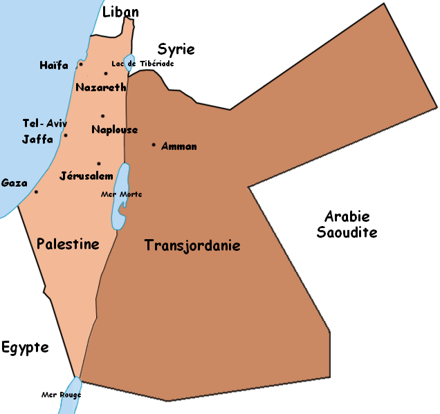
Français : Carte de la Palestine mandataire et de l'Emirat de Transjordanie tels que furent leurs frontières entre 1922 et 1948. |
| Date | 17 October 2006 (original upload date) |
| Source | La carte a été réalisée par moi-même à partir de en:Image:BritishMandatePalestine1920.jpg créée par Ramallite. Ceedjee contact 21 décembre 2006 à 00:38 (CET) |
| Author | The original uploader was Ceedjee at French Wikipedia. |
Licensing edit
.PNG&action=edit§ion=2)

|
Permission is granted to copy, distribute and/or modify this document under the terms of the GNU Free Documentation License, Version 1.2 or any later version published by the Free Software Foundation; with no Invariant Sections, no Front-Cover Texts, and no Back-Cover Texts. A copy of the license is included in the section entitled GNU Free Documentation License. |
| This file is licensed under the Creative Commons Attribution-Share Alike 3.0 Unported license. | ||
| ||
| This licensing tag was added to this file as part of the GFDL licensing update. |
Original upload log edit
.PNG&action=edit§ion=3)
Transferred from fr.wikipedia to Commons by Bloody-libu using CommonsHelper.
The original description page was here. All following user names refer to fr.wikipedia.
- 2011-01-29 16:48 Vadac 636×599× (60777 bytes) fixed border of Transjordan with Saudi Arabia
- 2006-10-17 20:54 Ceedjee 636×599× (73898 bytes) Carte de la Palestine mandataire et de l'Emirat de Transjordanie tels que furent leurs frontières entre 1922 et 1948.
File history
Click on a date/time to view the file as it appeared at that time.
| Date/Time | Thumbnail | Dimensions | User | Comment | |
|---|---|---|---|---|---|
| current | 14:12, 20 August 2012 | | 636 × 599 (59 KB) | File Upload Bot (Magnus Manske) (talk | contribs) | Transfered from fr.wikipedia by User:Bloody-libu using CommonsHelper |
You cannot overwrite this file.
File usage on Commons
The following 18 pages use this file:
- Category:1993 in the State of Palestine
- Category:Airports in Palestine
- Category:Bilateral relations of Palestine
- Category:Crime in the State of Palestine
- Category:Disasters and accidents in Palestine
- Category:Early photographers in Palestine
- Category:Economy of Palestine
- Category:Films of Palestine
- Category:Human rights activists from Palestine
- Category:Journalists from Palestine
- Category:Maps of Palestine
- Category:Monuments and memorials in Palestine
- Category:Muslims from Palestine
- Category:Palestine
- Category:Photographers from Palestine
- Category:Physicians from the State of Palestine
- Category:Swimmers from Palestine
- Category:Writers from the State of Palestine
File usage on other wikis
The following other wikis use this file:
- Usage on ar.wikipedia.org
- Usage on arz.wikipedia.org
- Usage on ast.wikipedia.org
- Usage on az.wikipedia.org
- Usage on ca.wikipedia.org
- Usage on eo.wikipedia.org
- Usage on fr.wikipedia.org
- Usage on fr.wikinews.org
- Usage on ga.wikipedia.org
- Usage on ha.wikipedia.org
- Usage on ia.wikipedia.org
- Usage on kab.wikipedia.org
- Usage on ru.wikipedia.org
- Usage on www.wikidata.org
.PNG&oldid=762408715)