File:Palmer Rd overpass and Bryn Mawr Market jeh.jpg

Size of this preview: 800 × 600 pixels. Other resolutions: 320 × 240 pixels | 640 × 480 pixels | 1,024 × 768 pixels | 1,280 × 960 pixels | 1,600 × 1,200 pixels.
Original file (1,600 × 1,200 pixels, file size: 1.47 MB, MIME type: image/jpeg)
Captions
Captions
Add a one-line explanation of what this file represents
Summary edit
| Description |
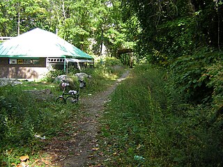
English: South County Trailway approximately halfway between the two paved portions, runs northward past a grocery building (designed to recall the former Bryn Mawr Park station of the New York and Putnam Railroad line), over the original Palmer Road grade crossing, under the middle 20th century overpass, towards the line's summit about half a mile north. Photographer's Brompton Bicycle in foreground. Unretouched. See File:Palmerstub.JPG for a view from the southwest. |
| Date | 19 October 2007 (original upload date) |
| Source | Transferred from en.wikipedia to Commons. |
| Author | Jim.henderson at English Wikipedia |
| Other versions |
|
| Camera location | | View this and other nearby images on: OpenStreetMap |
|---|
Licensing edit
Jim.henderson at the English Wikipedia, the copyright holder of this work, hereby publishes it under the following license:

|
Permission is granted to copy, distribute and/or modify this document under the terms of the GNU Free Documentation License, Version 1.2 or any later version published by the Free Software Foundation; with no Invariant Sections, no Front-Cover Texts, and no Back-Cover Texts. A copy of the license is included in the section entitled GNU Free Documentation License. |
| This file is licensed under the Creative Commons Attribution-Share Alike 3.0 Unported license. | ||
| Attribution: Jim.henderson at the English Wikipedia | ||
| ||
| This licensing tag was added to this file as part of the GFDL licensing update. |
Original upload log edit
The original description page was here. All following user names refer to en.wikipedia.
- 2007-10-19 06:11 Jim.henderson 1600×1200× (1544375 bytes) [[South County Trailway]] approximately halfway between the two paved portions, runs past the former Bryn Mawr Park station of the [[New York and Putnam Railroad]] line, over the original grade crossing, under the middle 20th century overpass, towards the
File history
Click on a date/time to view the file as it appeared at that time.
| Date/Time | Thumbnail | Dimensions | User | Comment | |
|---|---|---|---|---|---|
| current | 20:25, 5 September 2010 | | 1,600 × 1,200 (1.47 MB) | DanTD (talk | contribs) | {{Information |Description={{en|en:South County Trailway approximately halfway between the two paved portions, runs past a grocery building desgined to recall the former Bryn Mawr Park station of the en:New York and Putnam Railroad line, over |
You cannot overwrite this file.
File usage on Commons
The following page uses this file:
- File:Palmerover.jpg (file redirect)
File usage on other wikis
The following other wikis use this file:
- Usage on en.wikipedia.org