File:Pamukkale 006.JPG

Original file (3,872 × 2,592 pixels, file size: 3.5 MB, MIME type: image/jpeg)
Captions
Captions
Summary edit
| Description |
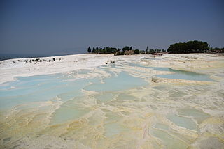
Nederlands: Pamukkale betekent "kasteel van katoen" in het Turks en is een natuurfenomeen in Turkije. Pamukkale ligt ten noorden van Denizli in Turkije.
Het sterk kalkhoudende water loopt er via een groot aantal terrassen van een helling. English: Pamukkale, meaning "cotton castle" in Turkish, is a natural site in southwestern Turkey. The city contains hot springs and travertines, terraces of carbonate minerals left by the flowing water. |
| Date | |
| Source | Own work |
| Author | Ad Meskens/Eva Meskens |
| Permission (Reusing this file) |
You are free to use this picture for any purpose as long as you credit its author, Ad Meskens. Example: © Ad Meskens / Wikimedia Commons
This file has been released under a license which is incompatible with Facebook's licensing terms. It is not permitted to upload this file to Facebook.
|

|
This place is a UNESCO World Heritage Site, listed as
Pamukkale.
|
| Camera location | | View this and other nearby images on: OpenStreetMap |
|---|
Licensing edit
- You are free:
- to share – to copy, distribute and transmit the work
- to remix – to adapt the work
- Under the following conditions:
- attribution – You must give appropriate credit, provide a link to the license, and indicate if changes were made. You may do so in any reasonable manner, but not in any way that suggests the licensor endorses you or your use.
- share alike – If you remix, transform, or build upon the material, you must distribute your contributions under the same or compatible license as the original.
File history
Click on a date/time to view the file as it appeared at that time.
| Date/Time | Thumbnail | Dimensions | User | Comment | |
|---|---|---|---|---|---|
| current | 20:39, 4 October 2013 | | 3,872 × 2,592 (3.5 MB) | Ad Meskens (talk | contribs) | User created page with UploadWizard |
You cannot overwrite this file.
File usage on Commons
The following page uses this file: