File:Pannonia02.png

Size of this preview: 668 × 599 pixels. Other resolutions: 268 × 240 pixels | 535 × 480 pixels | 1,001 × 898 pixels.
Original file (1,001 × 898 pixels, file size: 75 KB, MIME type: image/png)
Captions
Captions
Add a one-line explanation of what this file represents
Summary edit
| Description |
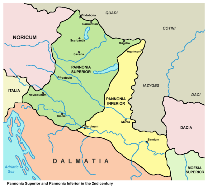
English: Historic map - Roman provinces Pannonia Superior and Pannonia Inferior in the 2nd century.
Српски / srpski: Istorijska karta - Rimske provincije Gornja Panonija i Donja Panonija u 2. veku. |
||
| Date | |||
| Source |
|
||
| Author | PANONIAN (talk · contribs) |

Licensing edit
| I, the copyright holder of this work, release this work into the public domain. This applies worldwide. In some countries this may not be legally possible; if so: I grant anyone the right to use this work for any purpose, without any conditions, unless such conditions are required by law. |
File history
Click on a date/time to view the file as it appeared at that time.
| Date/Time | Thumbnail | Dimensions | User | Comment | |
|---|---|---|---|---|---|
| current | 15:54, 8 April 2010 | | 1,001 × 898 (75 KB) | PANONIAN (talk | contribs) | improved version |
| 14:34, 26 July 2007 |  | 702 × 751 (12 KB) | Nihad Hamzic (talk | contribs) | Losslessly reduced the color domain to 4-bit. The file size is much smaller. | |
| 23:54, 23 December 2006 |  | 702 × 751 (39 KB) | Electionworld (talk | contribs) | {{ew|en|PANONIAN}} historic map (self made) {{PD-self}} Category:Maps of the history of Vojvodina Category:Maps of the history of Serbia Category:Maps of the history of Croatia Category:Maps of the history of Bosnia and Herzegovina [[Categ |
You cannot overwrite this file.
File usage on Commons
The following 5 pages use this file:
File usage on other wikis
The following other wikis use this file:
- Usage on af.wikipedia.org
- Usage on ar.wikipedia.org
- Usage on ast.wikipedia.org
- Usage on be.wikipedia.org
- Usage on bg.wikipedia.org
- Usage on br.wikipedia.org
- Usage on ca.wikipedia.org
- Usage on cs.wikipedia.org
- Usage on el.wikipedia.org
- Usage on en.wikipedia.org
- Usage on et.wikipedia.org
- Usage on fa.wikipedia.org
- Usage on fi.wikipedia.org
- Usage on fr.wikipedia.org
- Usage on fr.wiktionary.org
- Usage on gl.wikipedia.org
- Usage on hr.wikipedia.org
- Usage on hu.wikipedia.org
- Usage on it.wikipedia.org
- Usage on ja.wikipedia.org
- Usage on ka.wikipedia.org
- Usage on ko.wikipedia.org
- Usage on la.wikipedia.org
View more global usage of this file.