File:Pannonian sea02.png

Size of this preview: 800 × 530 pixels. Other resolutions: 320 × 212 pixels | 640 × 424 pixels | 1,024 × 679 pixels | 1,399 × 927 pixels.
Original file (1,399 × 927 pixels, file size: 84 KB, MIME type: image/png)
Captions
Captions
Add a one-line explanation of what this file represents
Summary edit
| Description |
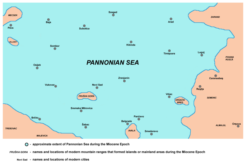
English: detailed map of the south-eastern part of Pannonian Sea during the Miocene Epoch.
Српски / srpski: детаљна мапа југоисточног дела Панонског мора током епохе миоцена. |
| Date | 11 July 2009 (original upload date) |
| Source | Own work |
| Author | PANONIAN |
References edit
Published references:
- Dragan Rodić, Geografija za I ili III razred srednje škole, Beograd, 1995.
- Dr Dušan J. Popović, Srbi u Vojvodini, knjiga 1, Novi Sad, 1990.
- Dr Aleksa Ivić, Istorija Srba u Vojvodini, Novi Sad, 1929.
- Milan Tutorov, Mala Raška a u Banatu, Zrenjanin, 1991.
- Milan Tutorov, Banatska rapsodija - istorika Zrenjanina i Banata, Novi Sad, 2001.
- Predrag Medović, Praistorija na tlu Vojvodine, Novi Sad, 2001.
Internet references:
- http://www.sulinet.hu/oroksegtar/data/telepulesek_ertekei/Ruzsa/pages/ruzsa_tortenete_es_nepelete/003_termeszeti_foldrajz.htm
- http://www.geology.wisc.edu/~paleo/pannon.gif
- http://paleobiol.geoscienceworld.org/content/38/4/554/F1.large.jpg
- http://openi.nlm.nih.gov/imgs/512/2/3271360/3271360_gr1.png
- http://www.sciencedirect.com/science/article/pii/S0031018298001552
- http://origin-ars.els-cdn.com/content/image/1-s2.0-S0031018298001552-gr7.gif
- http://shebtiw.wordpress.com/2009/11/13/the-sea-in-the-6th-minute/
- http://shebtiw.files.wordpress.com/2009/11/basin.jpg
- http://de.wikipedia.org/w/index.php?title=Datei:Karte_Pannon_See_vor_11,5_Mio._Jahren.JPG&filetimestamp=20051220124116[dead link]
Licensing edit
| I, the copyright holder of this work, release this work into the public domain. This applies worldwide. In some countries this may not be legally possible; if so: I grant anyone the right to use this work for any purpose, without any conditions, unless such conditions are required by law. |
File history
Click on a date/time to view the file as it appeared at that time.
| Date/Time | Thumbnail | Dimensions | User | Comment | |
|---|---|---|---|---|---|
| current | 10:18, 23 November 2013 | | 1,399 × 927 (84 KB) | PANONIAN (talk | contribs) | corrections |
| 10:47, 12 November 2013 |  | 1,399 × 927 (84 KB) | PANONIAN (talk | contribs) | aesthetics | |
| 04:22, 21 July 2009 |  | 1,403 × 927 (84 KB) | PANONIAN (talk | contribs) |
You cannot overwrite this file.
File usage on Commons
The following 4 pages use this file:
File usage on other wikis
The following other wikis use this file:
- Usage on el.wikipedia.org
- Usage on en.wikipedia.org
- Usage on fi.wikipedia.org
- Usage on fr.wikipedia.org
- Usage on hu.wikipedia.org
- Usage on pl.wikipedia.org
- Usage on ro.wikipedia.org
- Usage on ru.wikipedia.org
- Usage on sh.wikipedia.org
- Usage on sq.wikipedia.org
- Usage on uk.wikipedia.org