File:Paragon Mill, Jersey Street, Manchester.jpg
No higher resolution available.
Paragon_Mill,_Jersey_Street,_Manchester.jpg (640 × 473 pixels, file size: 193 KB, MIME type: image/jpeg)
Captions
Captions
Add a one-line explanation of what this file represents
Summary edit
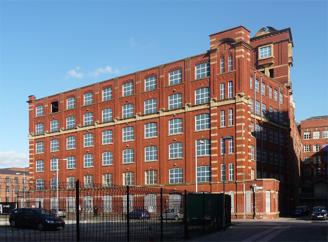
| Description |
English: Vigorous red brick with stone trim and some Baroque details such as the open pediment. Built by a Mr Porter of the Fine Cotton Spinners' Engineering Division, 1911-13. Underneath the brick is steel and concrete. Pevsner notes that the mill was "designed to house electrically powered mules, with electric motors housed in towers ... in the first generation of those purpose-built for electricity, which was supplied by the Corporation." Grade II* listed.
Almost all the 'windows' here are not real but painted. The plan is to convert it to flats. |
||
| Date | |||
| Source | https://www.geograph.org.uk/photo/2818262 | ||
| Author | Stephen Richards | ||
| Permission (Reusing this file) |
This file is licensed under the Creative Commons Attribution-Share Alike 2.0 Generic license. Attribution: Stephen Richards
|
||
| Attribution (required by the license) | Stephen Richards / Paragon Mill, Jersey Street, Manchester / | ||

| Camera location | | View this and other nearby images on: OpenStreetMap |
|---|
_heading:112.00&language=en)
| Object location | | View this and other nearby images on: OpenStreetMap |
|---|
_heading:112.00&language=en)
File history
Click on a date/time to view the file as it appeared at that time.
| Date/Time | Thumbnail | Dimensions | User | Comment | |
|---|---|---|---|---|---|
| current | 18:32, 3 December 2012 | | 640 × 473 (193 KB) | Delusion23 (talk | contribs) | User created page with UploadWizard |
You cannot overwrite this file.
File usage on Commons
The following page uses this file:
File usage on other wikis
The following other wikis use this file:
- Usage on dag.wikipedia.org
- Usage on en.wikipedia.org
- Usage on www.wikidata.org