File:Paris Metro map.svg

Size of this PNG preview of this SVG file: 653 × 600 pixels. Other resolutions: 261 × 240 pixels | 523 × 480 pixels | 836 × 768 pixels | 1,115 × 1,024 pixels | 2,230 × 2,048 pixels | 1,927 × 1,770 pixels.
Original file (SVG file, nominally 1,927 × 1,770 pixels, file size: 309 KB)
Captions
Captions
Add a one-line explanation of what this file represents
| Description |
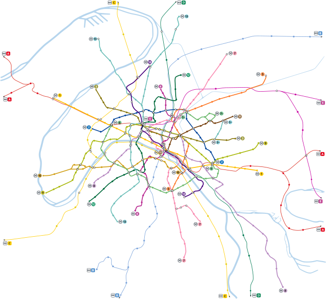
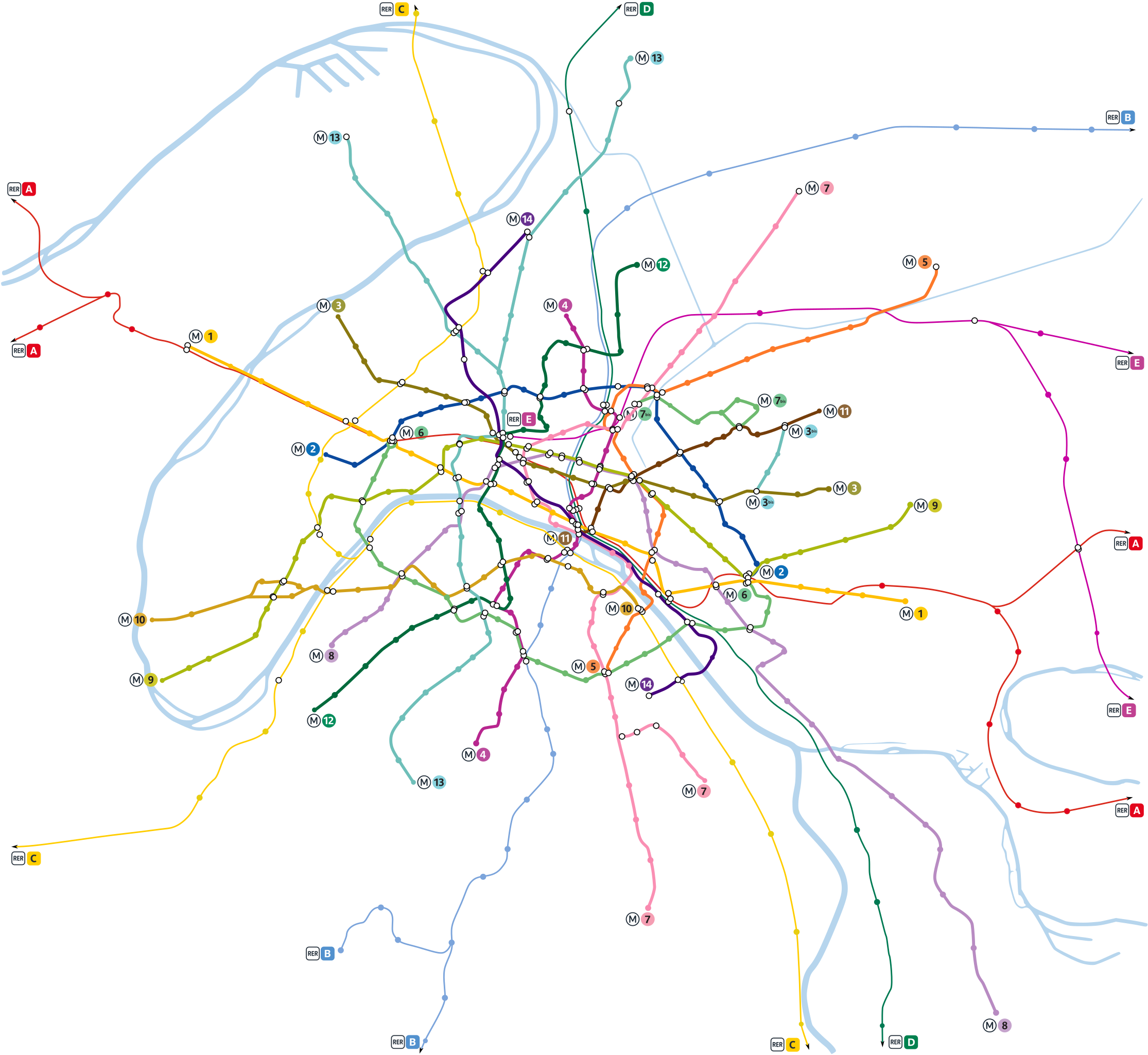
English: Paris metro network pictured at a geographically accurate scale.
Français : Plan du métro de Paris en repectant les proportions géographiques.
Русский: Карта парижского метрополитена и сети RER в географическом масштабе. |
||
| Date | |||
| Source | Vectorisation of Image:Paris Metro map.gif | ||
| Author | User:Pmx | ||
| Permission (Reusing this file) |
|
||
| Other versions |
  |
This W3C-unspecified vector image was created with Inkscape .
File history
Click on a date/time to view the file as it appeared at that time.
| Date/Time | Thumbnail | Dimensions | User | Comment | |
|---|---|---|---|---|---|
| current | 08:35, 14 May 2022 | | 1,927 × 1,770 (309 KB) | Lyon-St-Clair (talk | contribs) | New line signs since 2019/2020 |
| 09:33, 18 January 2021 |  | 1,927 × 1,770 (326 KB) | Julio974fr (talk | contribs) | New extensions | |
| 11:25, 10 January 2010 |  | 1,927 × 1,770 (342 KB) | Greenski (talk | contribs) | Using of the goods paris metro signs, changing rer A color. | |
| 00:54, 22 June 2008 |  | 1,927 × 1,770 (321 KB) | Gonioul (talk | contribs) | split to multiple layers, thickens metro paths | |
| 22:16, 21 June 2008 |  | 1,927 × 1,770 (222 KB) | Gonioul (talk | contribs) | grey background is bad for readability | |
| 18:46, 13 June 2008 |  | 1,927 × 1,770 (222 KB) | Otourly (talk | contribs) | Mise à jour | |
| 20:59, 13 July 2007 |  | 1,927 × 1,770 (219 KB) | Pmx (talk | contribs) | {{Information |Description= {{en|Paris metro network pictured at a geographically accurate scale.}} {{fr|Plan du métro de Paris en vrai grandeur.}} |Source=Vectorisation of Image:Paris Metro map.gif |Date=13/07/07 |Author=User:Pmx |Permission=PD |
You cannot overwrite this file.
File usage on Commons
The following 11 pages use this file:
- Maps of Paris
- Paris Metro
- User:Chumwa/OgreBot/Public transport information/2021 January 11-20
- User:Chumwa/OgreBot/Public transport information/2022 May 11-20
- User:Chumwa/OgreBot/Transport Maps/2021 January 11-20
- User:Chumwa/OgreBot/Transport Maps/2022 May 11-20
- User:Paris 16/Paris
- User talk:Pi.1415926535/Archive 1
- File:Paris Metro map.gif
- File:Paris Metro map beschriftet.png
- File:Paris Metro map complete.svg
File usage on other wikis
The following other wikis use this file:
- Usage on cs.wikipedia.org
- Usage on de.wikipedia.org
- Usage on fr.wikipedia.org
- Métro de Paris
- Portail:Transports en Île-de-France
- Portail:Transports en Île-de-France/Introduction
- Portail:Transports en Île-de-France/Métro
- Utilisateur:Clicsouris/Bac à sable
- Wikipédia:Atelier graphique/Images à améliorer/Archives/Juin 2008
- Wikipédia:Atelier graphique/Cartes/Archives/Demandes mises en sommeil
- Wikipédia:Atelier graphique/Cartes/Archives/juillet 2009
- Réseau (homonymie)
- Wikipédia:Atelier graphique/Cartes/Archives/juin 2016
- Usage on it.wikipedia.org
- Usage on zh.wikipedia.org