File:Passchendaele aerial view.jpg
Original file (500 × 674 pixels, file size: 317 KB, MIME type: image/jpeg)
Captions
Captions
|

|
This image has been assessed under the valued image criteria and is considered the most valued image on Commons within the scope: the Battle of Passchendaele. You can see its nomination here. |
| Description |
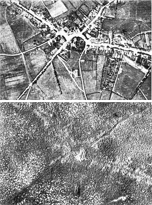
English: Aerial view of the village of Passchendaele (north is to the right of the photo) before and after the Third Battle of Ypres, 1917.
Français : Vue aerienne du village de Passendale, avant et après la troisième bataille d'Ypres, en 1917. Le nord est à droite sur les photos. |
|||
| Date | ||||
| Source |
|
|||
| Author | Photographer not identified. "Official photograph". | |||
| Permission (Reusing this file) |
|
|||
| Other versions |
|


| Camera location | | View this and other nearby images on: OpenStreetMap |
|---|
File history
Click on a date/time to view the file as it appeared at that time.
| Date/Time | Thumbnail | Dimensions | User | Comment | |
|---|---|---|---|---|---|
| current | 17:33, 22 December 2011 | | 500 × 674 (317 KB) | Soerfm (talk | contribs) | Sharpness |
| 11:23, 25 April 2005 |  | 500 × 674 (290 KB) | Gsl~commonswiki (talk | contribs) | Second version: Lightened and set levels. Sharpened slightly (by w:User:Ian Dunster) | |
| 11:21, 25 April 2005 |  | 500 × 674 (81 KB) | Gsl~commonswiki (talk | contribs) | Original version from en.wikipedia.org |
You cannot overwrite this file.
File usage on Commons
The following 11 pages use this file:
- Third Battle of Ypres
- User:M0tty/WWI
- User talk:Slaunger/Valuable Images
- Commons:Featured picture candidates/Image:Passchendaele aerial view.jpg
- Commons:Featured picture candidates/Log/May 2007
- Commons:Valued image candidates/Passchendaele aerial view.jpg
- Commons:Valued image candidates/candidate list/log/2008/03
- Commons:Valued images by topic/Historical/Wars, revolutions and battles
- Category:Passendale
- Category:Second Battle of Passchendaele
- Category:Third Battle of Ypres
File usage on other wikis
The following other wikis use this file:
- Usage on ar.wikipedia.org
- Usage on ast.wikipedia.org
- Usage on az.wikipedia.org
- Usage on bg.wikipedia.org
- Usage on bn.wikipedia.org
- Usage on br.wikipedia.org
- Usage on ca.wikipedia.org
- Usage on cs.wikipedia.org
- Usage on da.wikipedia.org
- Usage on de.wikipedia.org
- Usage on el.wikipedia.org
- Usage on en.wikipedia.org
- Battle of Passchendaele
- Wikipedia:Featured picture candidates/October-2004
- Wikipedia:Picture of the day/November 2004
- Wikipedia:Picture of the day/November 7, 2004
- Wikipedia:POTD/November 7, 2004
- Alexander Edwards
- Wikipedia:Picture of the day/February 2005
- Wikipedia:POTD/February 21, 2005
- Wikipedia:Picture of the day/February 21, 2005
- Wikipedia:Picture of the day/December 2005
- Wikipedia:Picture of the day/December 21, 2005
- Wikipedia:POTD/December 21, 2005
- User:Cyde/Featured pictures
- Passendale
- Portal:United Kingdom/Featured picture/12
- Portal:United Kingdom/Featured picture
- Second Battle of Passchendaele
- Wikipedia:Featured picture candidates/delist/2008
- Wikipedia:Featured picture candidates/delist/Village of Passchendaele
- User talk:Durova/Archive 61
- Wikipedia:Featured picture candidates/delist/2009
- Wikipedia:Featured picture candidates/delist/File:Passchendaele aerial view.jpg
- User:Durova/FPC survey
- Wikipedia talk:Valued picture candidates/Archive 3
- Wikipedia:Featured picture candidates/delist/2015
- Wikipedia:Featured picture candidates/delist/Passchendaele
- Night action of 1/2 December 1917
- Usage on es.wikipedia.org
- Usage on fi.wikipedia.org
- Usage on fr.wikipedia.org
- Usage on fy.wikipedia.org
View more global usage of this file.